Schöllenen Gorge
[2] It formed the upper limit of Alemannic settlement in the Alps prior to the 12th century, and the border between the bishoprics of Constance and Raetia Curensis.
This path was forced to avoid the southern part of the gorge, taking a steep ascent from Brüggliwaldboden, climbing above 1,800 m before descending to Hospental via Bäzberg.
This was of great strategic importance because it opened the Gotthard Pass, with historical consequences both regionally and to the Italian politics of the Holy Roman Empire.
Robert Schedler published a historical novel surrounding the construction of the Schöllenen bridle path, Der Schmied von Göschenen, in 1919.
According to Scheuchzer, he was told a local legend according to which the people of Uri recruited the Devil for the difficult task of building the bridge.
Lauf-Belart (1924) surmised that the name Teufelsbrücke was originally due to an erroneous interpretation by learned travellers, which only in the 17th century gave rise to the local legend involving the Devil.
This time, there was a broad movement to preserve it, and in 1971, federal authorities agreed to move the stone, with projected costs of 250,000 francs (of which the canton of Uri was to contribute 7,000).
The liberal newspaper Gotthard-Post proposed to spend the money on the construction of a retirement home instead, collecting 1,000 signatures in support.
The cantonal government now argued that there was no legal basis for the destruction of the stone because it had been the property of Naturforschende Gesellschaft Uri since 1925.
On St Patrick's Day (17 March) 1608, Hugh O'Neill, Earl of Tyrone, was fleeing from Ulster to Rome with 98 of his fellow-Gaels.
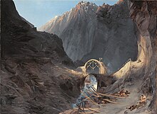
The tunnel, constructed by Pietro Morettini [it] (1660–1737) and known as the Urnerloch [de] ("Uri Hole"), was the first road-tunnel to be built in the Alps.
A replacement cut stone bridge was planned and executed by Karl Emanuel Müller (1804–1869), the cantonal engineer in charge of the stretch of the new Gotthard road between Göschenen and Hospental.