Texas Park Road 1
The highway is approximately 33.6 miles (54.1 km) long, and passes through mainly rural park land.
[5][6] The Texas Department of Transportation (TxDOT) publishes yearly reports of highway's annual average daily traffic (AADT), with counts usually taken near intersections.
The highest traveled point along the road is at PR 1C's intersection with County Route 174 (CR 174), with an average count of 690 vehicles.
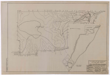
It continues north, providing access to several of the park's hiking trails and a scenic overlook, before it bends westward.
It travels past the park's barracks and several large camping areas, before reaching its terminus, an intersection that closes the loop.
[3] The highway begins at an intersection with PR 1A on the southwestern edge of Bastrop State Park Lake.
The route bends eastward, traveling to its northern terminus, a dead end spot at one of the cabins.
It bends northeastward while providing access to the Old Road Bed trail, which leads back to PR 1A.
The highway proceeds eastward into the "Lost Pines" portion of the park, where it occasionally intersects private roads.
The roadway bends southward before passing the western edge of the Stengl Lost Pines Biological Station.
The route makes a 180 degree bend past the dining hall, and passes north of the small clump of trees.
[4] The road begins at an intersection with PR 1C at the entrance to the Lakeview Camping Area, north of Park Lake.
The roadway passes the park amphitheater, and intersects a small road that leads to the Cozy Circle Camping Area.
The highway bends in a slight backwards S-shape, intersecting several roads that lead to park cabins, picnic areas, and other sites.
[16] On March 1, 1963, the portion of PR 1 from SH 71 to the south entrance to Buescher State Park was cancelled, with the new southern terminus becoming FM 153.