U.S. Route 290
It begins to travel due east through rural farmlands in the Texas Hill Country before reaching Harper, where it is the main west–east road in the town.
[2] Afterwards, US 290 begins making slight curves as it crosses through several creeks and tributaries amidst additional farmland, where it eventually joins US 87 and runs as Main Street through Fredericksburg.
[2] Traveling due south, US 290 returns to an eastward path after crossing the Pedernales River, where it serves as a major artery for Fredericksburg's agricultural district, including Wildseed Farms.
[2] The highway then runs parallel to the Pedernales River, and after passing Stonewall, serves the south side of LBJ Ranch.
[2] After traveling through additional hilly terrain, US 290 splits east from US 281 and twists through slopes in the Edwards Plateau, where an intersection with RM 3232 in the unincorporated community of Henly provides access to Pedernales Falls State Park.
[2] The highway then begins a concurrency with SH 71 at a series of traffic lights and travels through Austin's Oak Hill district before becoming a five-to-six-lane freeway.
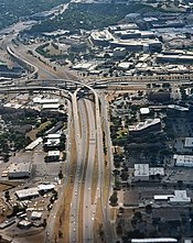
In the community of Sunset Valley, US 290 has interchanges with Loop 1 (MoPac Expressway) and Loop 360 (Capital of Texas Highway) providing access to the Barton Creek Greenbelt, and is then designated as Ben White Boulevard while it travels through south-central Austin, crossing the UPRR Austin Subdivision railroad in the process.
Just prior to bordering the east side of the main University of Texas at Austin campus, I-35 and US 290 split into two decks for about 2 miles (3.2 km), resurfacing close to the former Mueller Airport.
It then travels through much of industrial East Austin and Daffan before reverting to a four-lane divided highway after an interchange with SH 130, less than a mile shy of Manor.
[2] US 290 then makes its way through rolling meadows dotted with suburban areas in northeast Travis County, then travels through southern Elgin where it forms a brief concurrency with SH 95.
Passing through the town of McDade, US 290 cuts through piney woods north of the Lost Pines Forest and has an interchange with SH 21 west of Paige.
The highway then enters Brenham, where it briefly joins SH 36 to serve Blinn College and bypass the city as a four-lane freeway.
After exiting Brenham, US 290 runs parallel to the old Washington County Railroad and goes through Chappell Hill to serve every historic landmark there, then crosses the Brazos River to move through a rural auto-industrial area.
[2] SH 6 joins US 290 north of Hempstead, where the two highways become a four-lane freeway notable for its role as a hurricane evacuation route.
Running parallel to the Houston and Texas Central Railway from the north, US 290 finally comes right next to it roughly 3 miles (4.8 km) prior to intersecting SH 99.
The proposal included SH 20 originally planned as the Austin-Houston Highway between Austin and Houston by way of Bastrop, Giddings, Brenham, and Hempstead.
The following year, state lawmakers vest the department with the authority to acquire right of way, survey, plan, and build highways.
[19] In its original designation in the late 1920s, US 290 traveled from an intersection with US 80 in western Reeves County to an eastern terminus in San Antonio.
[1][24][25][26][27][28][29] In Austin, US 290 initially received two different freeway upgrades; the first took place circa the 1970s from the north interchange with I-35 near Highland Mall to US 183 east of the Coronado Hills district, while the second took place in the late 1990s and early 2000s from the Williamson Creek crossing in the Oak Hill district to the south interchange with I-35 near St. Edward's University.
The eastern terminus of US 290 was also approximately one mile to the southeast at the intersection of Hempstead Highway, Washington Avenue and Old Katy Road.
[32] In 2011, two members of the U.S. House of Representatives, John Culberson and Michael T. McCaul, asked TxDOT to advocate for the relabeling of US 290 as an interstate highway.
[42][43] At an intersection with SH 159, the business route turns east onto Austin Street and subsequently runs parallel to the adjacent railroad after leaving Hempstead city limits.