Thames Head
Their location is in fields near the villages of Coates and Kemble,[6] on either side of the A433 road, about three miles south-west of the town of Cirencester.
[9] During the 2022 United Kingdom heat wave, the source dried up completely, shifting five miles (eight kilometres) downstream to Somerford Keynes.
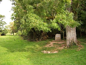
[10] The highest springs of Thames Head are located north of the A433 road (Fosse Way section), in a meadow called Trewsbury Mead.
One of these springs is marked with an inscribed stone marker, located 360 feet (110 m) above sea level at grid reference ST980994.
Others hold that the true source of the Thames is at Seven Springs, Gloucestershire, some 11 miles (18 km) farther north, and east of Gloucester.