The Blue Marble
The Blue Marble is a photograph of Earth taken on December 7, 1972, by either Ron Evans or Harrison Schmitt aboard the Apollo 17 spacecraft on its way to the Moon.
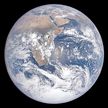
[2][3] In the original NASA image, named AS17-148-22727 and centered at about 26°19′49″S 37°25′13″E / 26.33028°S 37.42028°E / -26.33028; 37.42028 with the South Pole facing upwards, The Blue Marble shows Earth from the Mediterranean Sea to Antarctica.
This was the first time the Apollo trajectory made it possible to photograph the south polar ice cap, despite the Southern Hemisphere being heavily covered in clouds.
In addition to the Arabian Peninsula and Madagascar, almost the entire coastline of Africa and most of the Indian Ocean are clearly visible, a cyclone in the Indian Ocean is also visible, the South Asian mainland and Australia is on the eastern limb, and the eastern part of South America lies on the western limb.
[3] The astronauts had the Earth's South Pole facing upwards and the Sun above them (in spatial navigation terms, to their zenith)[6] when they took the image.
He got inspired during an LSD trip, seeing a "psychedelic illusion" of the Earth's curvature, convincing him that a picture of the entire planet would change how humans related to it.
[2] Today, as speculated by NASA archivist Mike Gentry, The Blue Marble is among the most widely distributed images in history.
[20] Alternatively, Eric Hartwell has identified it as having been taken slightly earlier at 5 hours 3 minutes, when one crew member states having changed the f-number, presumably between AS17-148-22725, the first of the series of photos, and the following less exposed images like the Blue Marble.
[3] All crew members, Gene Cernan, Ronald Evans and Harrison Schmitt, took photographs during the mission with the onboard Hasselblad.
[36] On February 2, 2012, NASA released a companion to this new Blue Marble, showing a composite image of the Eastern Hemisphere from data obtained on January 23, 2012.
[37] The picture is composed of data obtained by the Visible/Infrared Imager Radiometer Suite (VIIRS) instrument on board the Suomi NPP satellite on January 4, 2012.
[41] The data was acquired by the Suomi NPP satellite in April and October 2012 and then mapped over existing Blue Marble imagery of Earth to provide a realistic view of the planet.
[42] The Suomi NPP satellite completed 312 orbits and gathered 2.5 terabytes of data to get a clear shot of every parcel of the Earth's land surface.
[43] The nighttime views were obtained with the new satellite's "day-night band" of the Visible Infrared Imaging Radiometer Suite (VIIRS), which detects light in a range of wavelengths from green to near-infrared, and uses filtering techniques to observe dim signals such as city lights, gas flares, auroras, wildfires, and reflected moonlight.
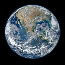
The Western United States, Mexico and the Caribbean are visible, but much of South America is hidden beneath cloud cover.
Clearly visible are storms forming over the Atlantic and Pacific Oceans, major slowly moving "cloud rivers", dust aerosol plumes from Africa, the Sun's reflection in the oceans, ship exhaust tracks in the clouds, rivers and lakes, and the variegated land surface patterns especially in the African deserts.