Cairngorms
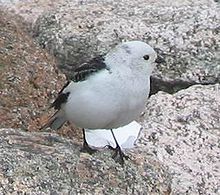
[5] This area is home to bird species such as ptarmigan, dotterel, snow bunting, curlew and red grouse, as well as mammals such as mountain hare.
[8] These forests support many species that are rare elsewhere in Britain, including red squirrels, pine marten, wood ants, Scottish crossbill, capercaillie and crested tit.
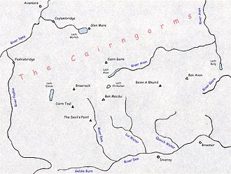
From the north-west, a road passes Coylumbridge, Glenmore and the Sugarbowl to end at the car park at the Cairngorm Mountain ski resort.
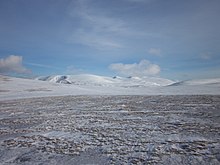
[20] The plateau area has a Tundra climate (Köppen ET),[21] and the shattered terrain is more like the high ground in high-arctic Canada or northern Norway than what is often observed in the European Alps or Rockies.
[22] The weather often deteriorates rapidly with elevation so that, when there are moderate conditions 150 m (490 ft) below the plateau, the top can be stormy or misty, and there can be icy or powdery snow.
What is often described as Britain's worst mountaineering tragedy, the Cairngorm Plateau Disaster, left five children and one adult dead in November 1971.
[32] The Cairngorms were formed 40 million years before the last ice age, when slight uplift raised an eroded peneplain based on an exposed granite pluton.
[38][39] Tors are a common feature of the Cairngorm granite massif, being especially frequent on Ben Avon and Beinn Mheadhoin and impressively high on Bynack More.
[40] The Cairngorms provide a unique alpine semi-tundra moorland habitat, home to many rare plants, birds and animals.
The most diverse lichen assemblages are found in the low-montane zone (750–900 m), particularly in prostrate Calluna vulgaris heath, where fruticose macrolichens are co-dominant with vascular plants.
[46] Mar Lodge Estate, which covers the south side of the plateau and the watershed of the upper Dee has been classified as a national nature reserve since May 2017.
[46] The Invereshie and Inshriach National Nature Reserve lies on the western flanks of the range, and extends to the summit of Sgòr Gaoith.
[citation needed] Other man-made threats include the problems of popularity in a country with limited wilderness resources and a large, relatively affluent urban population.
These include various types of recreation and the associated trampling damage and erosion, disturbance, litter and threats to water quality.
[51] The valleys between the individual plateaux were used as drove roads by cattle drovers who built rough protective shelters for their arduous journeys.
At about the same time that droving was dying out towards the end of the 19th century, deer stalking estates were flourishing, and so the shelters were developed into bothies to provide improved, though still primitive, accommodation for gamekeepers.
A condition was therefore imposed under which walkers were not allowed outside the top station if arriving by funicular, although this did not apply to skiers and snowboarders in the winter.
[54] In 2010 the operating company proposed to modify this requirement to allow guided walks, whilst still preventing general access.
[55] The mountains are very popular for hill-walking, with eighteen Munros lying between Ben Avon in the east and Glen Feshie in the west.
This area boasts what was for a time probably the world's hardest traditionally protected mixed climb: "The Hurting", grade XI.