The Catlins
A rugged, sparsely populated area, the Catlins features a scenic coastal landscape and dense temperate rainforest, both of which harbour many endangered species of birds, most notably the rare yellow-eyed penguin.
Its exposed location leads to its frequently wild weather and heavy ocean swells, which are an attraction to big-wave surfers, and have also caused numerous shipwrecks.
Prior to European settlement, the region was sparsely inhabited by nomadic groups of Māori, most of whom lived close to river mouths.
In the early days of European settlement the area was frequented by whalers and sealers, and saw milling became a major local industry from the mid-19th century until the 1930s.
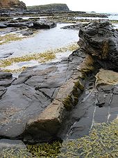
The rugged, scenic coastline of the Catlins features sandy beaches, blowholes, a petrified forest at Curio Bay, and the Cathedral Caves, which visitors can reach at low tide.
The highest point in the Catlins, Mount Pye (720 m or 2,360 ft)[4] stands 25 km (16 mi) north-northeast of Waikawa and close to the source of the Mokoreta River, and marks part of the Otago-Southland border.
[10] Shipping has found the Catlins coast notoriously dangerous, and many shipwrecks have occurred on the headlands that jut into the Pacific Ocean here.
The Waipapa Point light, which stands only 21 m (69 ft) above sea level, was the last wooden lighthouse to be built in New Zealand, and was constructed in 1884 in response to the tragic 1881 wreck of the Tararua.
Due to its position at the southern tip of New Zealand, the Catlins coastline lies exposed to some of the country's largest ocean swells, often over 5 m (16 ft).
[12] The region has enjoyed a growing reputation for big wave surfing,[13] with regular competitions,[14] award-winning rides,[15] and coverage on the Discovery Channel gathering publicity for the sport.
[22][23] The Catlins has a cool maritime temperate climate, somewhat cooler than other parts of the South Island, and strongly modified by the effect of the Pacific Ocean.
[26] Snow is rare except on the peaks even in the coldest part of winter, though frost is quite common during the months of June to September.
No formal Māori pā (villages) were located in the Catlins, but there were many hunting camps, notably at Papatowai, near the mouth of the Tahakopa River.
He purchased an extensive block of land along Catlins River on 15 February 1840 from Kāi Tahu chief Hone Tūhawaiki (also known as "Bloody Jack") for muskets and £30 (roughly NZ$3000 in 2005 dollars).
Most notably, one of New Zealand's worst shipping disasters occurred here: the wreck of the passenger-steamer Tararua, en route from Bluff to Port Chalmers, which foundered off Waipapa Point on 29 April 1881 with the loss of all but 20 of the 151 people aboard.
[43] Medical pioneer Dr Truby King established a farm at Tahakopa and a Catlins timber mill from the 1890s to the 1920s, and gave some of his mental patients vocational training there.
The trapping of rabbits and auctioning of their skins in Dunedin became a minor but important part of the Catlins area's economy during this time.
[54] The forest is thick with trees such as rimu (Dacrydium cupressinum), tōtara (Podocarpus totara), silver beech (Nothofagus), mataī (Prumnopitys taxifolia) and kahikatea (Dacrycarpus dacrydioides).
Plant life here includes many native species adapted to the strong salt-laden winds found in this exposed region.
[59] The geology of the Catlins dates back to over 150 million years ago, when the bedrock of the New Zealand continent was being assembled by thick sediments and volcanic arcs accreting onto the edge of the Gondwana supercontinent in a series of long thin terranes.
[61] The north-eastern boundary of this geologic region is marked by the Murihiku escarpment, which runs along the southern edge of the dormant Hillfoot fault line.
[62] The Catlins ranges are strike ridges composed of Triassic and Jurassic sandstones, mudstones and other related sedimentary rocks, often with a high incidence of feldspar.
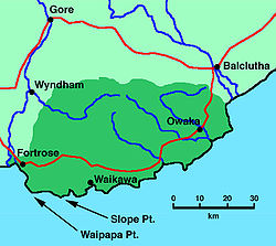
The only other settlements of any great size are Kaka Point (population 231),[66] Waikawa, Tokanui, and Fortrose, which lies at the western edge of the Catlins on the estuary of the Mataura River.
An outdoor education centre, run by the Otago Youth Adventure Trust is located at Tautuku, almost exactly halfway between Owaka and Waikawa.
Considerable sheep and dairy farming continues on the cleared hills on the periphery of the region, and this accounts for much of the Catlins' income.
[75] Several of the area's coastal settlements have facilities for small boats, but generally only fishing and holiday craft use them; no regular passenger or freight-boat service runs to the Catlins.
The Molyneux Constituency of the ORC, which covers roughly the same area as the Clutha District, elects two councillors to the 12-member Regional Council.
[81] Approximately the westernmost one-third of the Catlins area lies in the Southland District, based in Invercargill, 50 km (31 mi) to the west of Fortrose.
The Southern Constituency of the SRC, which covers the entire Toetoes Ward and extends across the Awarua Plain almost as far as Bluff in the west and Mataura in the north, elects one councillor to the 12-member Regional Council.
The nearest tertiary institution is Telford Rural Polytechnic, located at the edge of the Catlins at Otanomomo, south of Balclutha.