Tibet
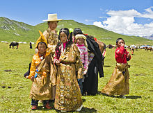
Also resident on the plateau are other ethnic groups such as Mongols, Monpa, Tamang, Qiang, Sherpa, Lhoba, and since the 20th century Han Chinese and Hui.
The bulk of western and central Tibet (Ü-Tsang) was often at least nominally unified under a series of Tibetan governments in Lhasa, Shigatse, or nearby locations.
[30] The history of a unified Tibet begins with the rule of Songtsen Gampo (604–650 CE), who united parts of the Yarlung River Valley and founded the Tibetan Empire.
[33] In 747, the hold of Tibet was loosened by the campaign of general Gao Xianzhi, who tried to re-open the direct communications between Central Asia and Kashmir.
At its height in the 780s to 790s, the Tibetan Empire reached its highest glory when it ruled and controlled a territory stretching from modern-day Afghanistan, Bangladesh, Bhutan, Burma, China, India, Nepal, Pakistan, Kazakhstan, Kyrgyzstan, Tajikistan.
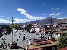
A bilingual account of this treaty, including details of the borders between the two countries, is inscribed on a stone pillar which stands outside the Jokhang temple in Lhasa.
The period that followed is known traditionally as the Era of Fragmentation, when political control over Tibet became divided between regional warlords and tribes with no dominant centralized authority.
[35] The Sakya lama retained a degree of autonomy, acting as the political authority of the region, while the dpon-chen held administrative and military power.
[37] Following the uprising, Tai Situ Changchub Gyaltsen founded the Phagmodrupa dynasty, and sought to reduce Yuan influences over Tibetan culture and politics.
In 1565 they were overthrown by the Tsangpa dynasty of Shigatse which expanded its power in different directions of Tibet in the following decades and favoured the Karma Kagyu sect.
With Güshi Khan as a largely uninvolved overlord, the 5th Dalai Lama and his intimates established a civil administration which is referred to by historians as the Lhasa state.
In 1750, the Ambans and the majority of the Han Chinese and Manchus living in Lhasa were killed in a riot, and Qing troops arrived quickly and suppressed the rebels in the next year.
The Qing commander publicly executed a number of supporters of the rebels and, as in 1723 and 1728, made changes in the political structure and drew up a formal organization plan.
The Qing now restored the Dalai Lama as ruler, leading the governing council called Kashag,[41] but elevated the role of Ambans to include more direct involvement in Tibetan internal affairs.
Seven years later, a Sikh army led by General Zorawar Singh invaded western Tibet from Ladakh, starting the Sino-Sikh War.
Although the expedition initially set out with the stated purpose of resolving border disputes between Tibet and Sikkim, it quickly turned into a military invasion.
The British expeditionary force, consisting of mostly Indian troops, quickly invaded and captured Lhasa, with the Dalai Lama fleeing to the countryside.
[52] In 1910, the Qing government sent a military expedition of its own under Zhao Erfeng to establish direct Manchu-Chinese rule and, in an imperial edict, deposed the Dalai Lama, who fled to British India.
During this time, Tibet fought Chinese warlords for control of the ethnically Tibetan areas in Xikang and Qinghai (parts of Kham and Amdo) along the upper reaches of the Yangtze River.
[57] In 1914, the Tibetan government signed the Simla Convention with Britain, which recognized Chinese suzerainty over Tibet in return for a border settlement.
[59] On December 20, 1941, Kuomintang leader Chiang Kai-Shek noted in his diary that Tibet would be among the territories which he would demand as restitution for China following the conclusion of World War II.
[67] In 1980, General Secretary and reformist Hu Yaobang visited Tibet and ushered in a period of social, political, and economic liberalization.
[citation needed] The climate is severely dry nine months of the year, and average annual snowfall is only 46 cm (18 inches), due to the rain shadow effect.
[citation needed] Sus scrofa expanded from its origin in southeast Asia into the Plateau, acquiring and fixing adaptive alleles for the high-altitude environment.
Ü-Tsang (dBus gTsang) (Ü in the center, Tsang in the center-west, and Ngari (mNga' ris) in the far west) covered the central and western portion of Tibet Autonomous Region.
Other cities and towns in cultural Tibet include Shiquanhe (Gar), Nagchu, Bamda, Rutog, Nyingchi, Nedong, Coqên, Barkam, Sagya, Gertse, Pelbar, Lhatse, and Tingri; in Sichuan, Kangding (Dartsedo); in Qinghai, Jyekundo (Yushu), Machen, and Golmud; in India, Tawang, Leh, and Gangtok, and in Pakistan, Skardu, Kharmang, and Khaplu.
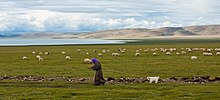
Due to limited arable land, the primary occupation of the Tibetan Plateau is raising livestock, such as sheep, cattle, goats, camels, yaks, dzo, and horses.
[111] It was reported in June 2021 that amidst the 2020–2022 China–India skirmishes, the People's Liberation Army had been forming a new unit for Tibetans who would be taken to Buddhist monks for religious blessings after completing their training.
Portuguese missionaries Jesuit Father António de Andrade and Brother Manuel Marques first reached the kingdom of Gelu in western Tibet in 1624 and was welcomed by the royal family who allowed them to build a church later on.
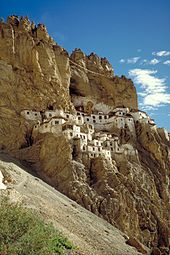
The most distinctive feature of Tibetan architecture is that many of the houses and monasteries are built on elevated, sunny sites facing the south, and are often made out of a mixture of rocks, wood, cement and earth.