Tibetan Plateau
[d] Geographically, it is located to the north of Himalayas and the Indian subcontinent, and to the south of Tarim Basin and Mongolian Plateau.
It is the world's highest and largest plateau above sea level, with an area of 2,500,000 square kilometres (970,000 sq mi).
North of the mountains runs the Gansu or Hexi Corridor which was the main silk-road route from China proper to the West.
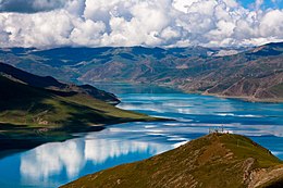
The plateau is a high-altitude arid steppe interspersed with mountain ranges and large brackish lakes.
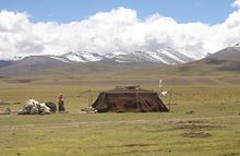
The southern and eastern edges of the steppe have grasslands that can sustainably support populations of nomadic herdsmen, although frost occurs for six months of the year.
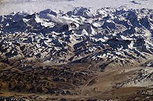
The Himalayas belong to the Alpine Orogeny and are therefore among the younger mountain ranges on the planet, consisting mostly of uplifted sedimentary and metamorphic rock.
During this early stage of its formation in the Late Palaeogene, Tibet consisted of a deep palaeovalley bounded by multiple mountain ranges rather than the more topographically uniform elevated flatland that it is today.
[21] The Tibetan Plateau's mean elevation continued to vary since its initial uplift in the Eocene; isotopic records show the plateau's altitude was around 3,000 metres above sea level around the Oligocene-Miocene boundary and that it fell by 900 metres between 25.5 and 21.6 million years ago, attributable to tectonic unroofing from east–west extension or to erosion from climatic weathering.
[23] The age of east–west grabens in the Lhasa and Himalaya terranes suggests that the plateau's elevation was close to its modern altitude by around 14 to 8 million years ago.
According to the former, the crust of the plateau is formed of several blocks with little internal deformation separated by major strike-slip faults.
[33] The presence of nomadic peoples on the plateau is predicated on their adaptation to survival on the world's grassland by raising livestock rather than crops, which are unsuitable to the terrain.
Archaeological evidence suggests that the earliest human occupation of the plateau occurred between 30,000 and 40,000 years ago.
Additionally, the specific heat capacity of liquid water is significantly greater than that of most materials that make up land.
The pressure anomaly then causes a steady wind to blow toward the land, which brings the moist air over the ocean surface with it.
When such lifting occurs, the air cools due to expansion in lower pressure, which in turn produces condensation and precipitation.
[36] Monsoons are similar to sea and land breezes, a term usually referring to the localized, diurnal cycle of circulation near coastlines everywhere, but they are much larger in scale, stronger and seasonal.
However, during the Last Glacial Maximum, an approximately 2,400,000 square kilometres (930,000 sq mi) ice sheet covered the plateau.
This lack of monsoon caused extensive rainfall over the Sahara, expansion of the Thar Desert, more dust deposited into the Arabian Sea, and a lowering of the biotic life zones on the Indian subcontinent.
Due to the extremely low biomass in those 15,000-year-old samples, it had taken around 5 years of research to extract 33 viruses, of which 28 were new to science.
In the long run, the glaciers are vital lifelines for Asian rivers, including the Indus and the Ganges.
Over the past five decades, 80% of the glaciers in the Tibetan Plateau have retreated, losing 4.5% of their combined areal coverage.