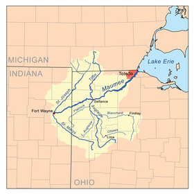
Tiffin River
The river drains a primarily rural farming region in the watershed of Lake Erie.
[3] The 56.3-mile-long (90.6 km)[1] upper section of the river north of the Ohio Turnpike is still referred to as Bean Creek.
[4] Bean Creek, the name of the upper half of the Tiffin River, flows from Devils Lake in the Irish Hills region of southeastern Michigan.
Turning south, the stream travels 8 miles (13 km) before merging with Hillsdale Creek just north of the city of Hudson.
Beginning a highly meandering course, the stream, now known as the Tiffin River, continues southwest toward the village of Stryker.