Timeline of the 1993 Atlantic hurricane season

[1][3] September 21 was the final date on which a system of at least tropical storm strength was active; this was described in a 1995 retrospective from Monthly Weather Review as the earliest such occurrence since 1930.

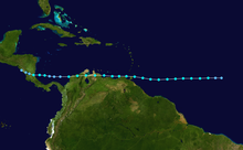
After hitting Nicaragua, Gert—a sprawling and moisture-laden tropical cyclone—generated heavy rainfall over a large portion of Central America and Mexico.

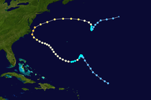
[11] At the end of the month, the western eyewall of Hurricane Emily passed over the Outer Banks of North Carolina while the storm was near its peak intensity; powerful winds and record-breaking floods caused three fatalities and heavy but localized damage.

Additionally, figures for maximum sustained winds and position estimates are rounded to the nearest five units (knots, miles, or kilometers) and averaged over one minute, following National Hurricane Center practice.

This timeline documents tropical cyclone formations, strengthening, weakening, landfalls, extratropical transitions, and dissipations during the season.

A satellite image of a tropical depression just to the northeast of the Bahamas
Satellite image of Tropical Depression One at peak intensity on June 1
A track map of a tropical storm over the western Gulf of Mexico; the overall path is northwestward
Storm path of Tropical Storm Arlene
A satellite image of a tropical storm off the northeast coast of South America
Satellite image of Tropical Storm Bret near peak intensity on August 6
A track map of a tropical storm that moves over the deep tropical Atlantic Ocean, extreme northern South America, and the extreme southern Caribbean Sea, ending over Nicaragua
Storm path of Tropical Storm Bret
A track map of a tropical storm that moves west-northwestward over the northeastern Caribbean Sea
Storm path of Tropical Storm Cindy
A track map of the path of a tropical storm over the southeastern portion of the Atlantic basin
Storm path of Tropical Storm Dennis
A satellite image of a hurricane near North Carolina
Satellite image of Hurricane Emily brushing the Outer Banks of North Carolina as a major hurricane on August 31
A track map of the erratic path of a hurricane over the western portion of the Atlantic basin
Storm path of Hurricane Emily
A satellite image of a hurricane over the northwestern Atlantic basin
Satellite image of Hurricane Floyd late on September 9
A track map of the path of a hurricane over the western Caribbean Sea, Central America, the Bay of Campeche, and central Mexico
Storm path of Hurricane Gert
A satellite image of a hurricane over southeastern Mexico and the adjacent waters of the Gulf of Mexico
Satellite image of Hurricane Gert approaching the Gulf coast of Mexico on September 20
A satellite image of a tropical storm over the northwestern portion of the Atlantic basin
Satellite image of Tropical Storm Harvey shortly before becoming a hurricane on September 20
A track map of the path of a northward-moving tropical depression over the central Atlantic basin
Storm path of Tropical Depression Ten