Lake Titicaca
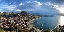
[8][9] The lake is located at the northern end of the endorheic Altiplano basin high in the Andes on the border of Peru and Bolivia.
The western part of the lake lies within the Puno Region of Peru, and the eastern side is located in the Bolivian La Paz Department.
Evapotranspiration, caused by strong winds and intense sunlight at high altitude, balances the remaining 90% of the water loss.
[16][17] Water pollution is also an increasing concern because cities in the Titicaca watershed grow, sometimes outpacing solid waste and sewage treatment infrastructure.
[18] According to the Global Nature Fund (GNF), Titicaca's biodiversity is threatened by water pollution and the introduction of new species by humans.
[19] A 2011 United Nations report found alarming concentrations of cadmium, arsenic, and lead in various parts of the lake.
[23] According to Weston La Barre, the Aymara considered in 1948 that the proper name of the lake is titiq’aq’a, which means gray, discolored, lead-colored puma.
This name survives in modern usage in which the large lake is occasionally referred to as Lago Chucuito.
For many years, the largest vessel afloat on Lake Titicaca was the 2,200-ton (2,425 U.S. tons), 79 m (259 ft) SS Ollanta.
[32] The Titicaca orestias has likely become extinct (last seen in 1938) due to competition and predation by the introduced rainbow trout and the silverside Odontesthes bonariensis.
[34] The many Orestias species in Lake Titicaca differ significantly in both habitat preference[35] and feeding behavior.
[43][44] Lacustrine sediments and associated terraces provide evidence for the past existence of five major prehistoric lakes that occupied the Tinajani Basin during the Pliocene and Pleistocene.
[48] These artifacts consist of ceramic feline incense burners, carved juvenile llamas, and well-crafted metal, shell, and stone ornaments.
During the fifteenth and sixteenth centuries, Lake Titicaca was a mythical place and the location of a pilgrimage complex for the Incas.
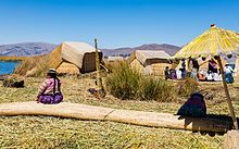
According to legend, the Uru people originated in the Amazon and migrated to the area of Lake Titicaca in the pre-Columbian era, where they were oppressed by the local population and were unable to secure land of their own.
[52] They built the sedge islands, which could be moved into deep water or to different parts of the lake, as necessary, for greater safety from their hostile neighbors on land.
Golden in color, many of the islands measure about 15 by 15 m (50 by 50 ft), and the largest are roughly half the size of a football field.
[52] As of 2011[update], about 1,200 Uros lived on an archipelago of 60 artificial islands,[52] clustering in the western corner of the lake near Puno, Titicaca's major Peruvian port town.
Some of the families on Amantani open their homes to tourists for overnight stays and provide cooked meals, arranged through tour guides.
Guests typically take food staples (cooking oil, rice, etc., but no sugar products, as they have no dental facilities) as a gift, or school supplies for the children on the island.
"Taquile and Its Textile Art" were honored by being proclaimed "Masterpieces of the Oral and Intangible Heritage of Humanity" by UNESCO.
Taquileans are also known for having created an innovative, community-controlled tourism model, offering home stays, transportation, and restaurants to tourists.
Ever since tourism started coming to Taquile in the 1970s, the Taquileños have slowly lost control over the mass day-tourism operated by non-Taquileans.
They have thus developed alternative tourism models, including lodging for groups, cultural activities, and local guides who have completed a 2-year training program.
The main economic activity of the approximately 800 families on the island is farming, with fishing and tourism augmenting the subsistence economy.
Among the ruins on the island are the Sacred Rock, a labyrinth-like building called Chinkana, Kasa Pata, and Pilco Kaima.
[citation needed] During 1987–92, Johan Reinhard directed underwater archaeological investigations off of the Island of the Sun, recovering Inca and Tiahuanaco offerings.
Pottery vessels of local dignitaries dating from this period have been excavated on islands in Lake Titicaca.
Craftsmen from Suriqui helped Thor Heyerdahl in the construction of several of his projects, such as the reed boats Ra II and Tigris, and a balloon gondola.
[60] Yavari was 30 m (100 ft) long, but in 1914 her hull was lengthened for extra cargo capacity and she was re-engined as a motor vessel.