Geography of Paris
The river's mouth on the English Channel (La Manche) is about 233 mi (375 km) downstream from the city.
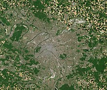
[2] Excluding the outlying parks of Bois de Boulogne and Bois de Vincennes, Paris covers an oval measuring about 87 km2 (34 sq mi) in area, enclosed by the 35 km (22 mi) ring road, the Boulevard Périphérique.
[3] The city's last major annexation of outlying territories in 1860 not only gave it its modern form but also created the 20 clockwise-spiralling arrondissements (municipal boroughs).
[8] In winter, sunshine is scarce; days are cool, nights cold but generally above freezing with low temperatures around 3 °C (37 °F).
[10] Paris has an average annual precipitation of 641 mm (25.2 in), and experiences light rainfall distributed evenly throughout the year.
[14] In the greater urban area, the highest point is in the Forest of Montmorency (Val-d'Oise département), 19.5 km (12.1 mi) north-northwest of the center of Paris as the crow flies, at 195 metres (640 ft) above sea level.
When the region is above sea-level, as at the present time, rivers draining water from the land form, and these cut channels into the landscape.
Many of the "hills" in Paris, appear to be formed as the result of cutoffs from previous meanders in the Seine river, which is now largely channelized to maintain its stability.