Toronto waterfront
[citation needed] Since the last ice age, silt deposits, borne mostly from the erosion of the Scarborough Bluffs and the eluvial rivers to the east were swept by strong, natural Lake Ontario currents creating prominent fingers of land away from the lakeshore in the current central waterfront area, including the Toronto Islands.
The shore of Lake Ontario (at least within present-day Toronto Harbour) is mostly landfill, extending a kilometre or more from the natural shoreline.
During this period, the Don River, which used to flow into the bay to the south-west, was diverted (straightened) toward the harbour, first directly southward and later westward through the current configuration of the Keating Channel.
Currently, there are proposals to restore the original natural watercourse of the Don, which would bring it closer to the downtown core.
The modern harbour area was mostly formed through landfill in the years around the First World War, to allow for deeper container vessel wharf access.
The central waterfront functioned as an important industrial area for many years, providing shipping access to communities from Port Union in the east to Mimico in the west.
West of the Humber River, outside the city limits, the waterfront has been mainly private lands fronting on the lake.
In the 1950s, the Gardiner Expressway project, connecting suburbs to the west, substantially changed the western waterfront.
This left behind many heavily polluted sites (some of the main uses of the waterfront were oil and coal storage, waste disposal and incineration, and heavy manufacturing especially in Toronto harbour).
Some buildings, such as Queen's Quay Terminal and Harbourfront Centre were remodeled, and others such as Maple Leaf Mills Silos demolished and replaced by new structures.
In 1988, Prime Minister Brian Mulroney called another Royal Commission into the waterfront that was headed by former mayor David Crombie.
Toronto's bids for the 1996 and 2008 Summer Olympics saw plans for much of the new facilities to be located along the waterfront, with all three levels of government committed to spending a great deal of money if the games were won, but on both attempts Toronto lost its bid due to the lack of diversity in facilities either planned or in situ and, except for further commercial condominium development at Harbourfront offering grandiose views of the water, the waterfront was unchanged.
Etobicoke Creek forms the western border of the city of Toronto dividing it with neighbouring Mississauga, and its portion of the Lake Ontario waterfront.
The neighbourhoods north of the lake are the former villages of Mimico, New Toronto and Long Branch, developed as suburbs of the original city.
While in close proximity to the lake, these areas are also just to the south of the industrial belt surrounding the CNR rail line.
More parkland along the lakeshore is being built with the goal to extend the waterfront route of Martin Goodman Trail as far west as Long Branch.
To the east of Exhibition Place begins a long stretch of former commercial and industrial areas that are rapidly being converted into some of Toronto's most expensive residences and condominiums.
Historic commercial structures such as the Tip Top Tailors Building and the Queen's Quay Terminal have been turned into luxury condominiums with waterfront views.
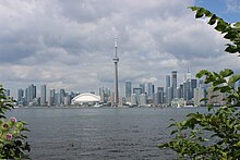
Between York and Yonge Streets is a cluster of large skyscrapers, many built in the 1970s in the first wave of redevelopment on the waterfront.
Controversy arose in 2003 when the port authority proposed replacing the ferry with a bridge, due to concerns about increased vehicle and air traffic along the waterfront.
This area is home to the shuttered Hearn Generating Station and the newly opened Portlands Energy Centre.
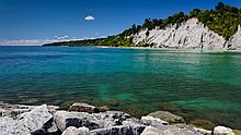
On the top of the cliffs are a number of suburban neighbourhoods such as Cliffside, Cliffcrest, Scarborough Village, Guildwood and West Hill.
This area is also home to large manicured properties such as Rosetta McClain Gardens and extensive grounds of the St. Augustine Seminary.
The eastern terminus of Lawrence Avenue is situated near the southeast portion of West Rouge's waterfront.
In 1972, the federal government established the "Harbourfront Project" which converted part of the central waterfront from industrial uses to cultural, recreational and residential uses.
The revitalization of Toronto's waterfront is one of the largest urban redevelopment project currently underway in North America with 800 hectares (2,000 acres) of largely underutilized, derelict land located steps away from Canada's largest financial and cultural urban core.
Full revitalization is projected to take 25 to 30 years and an estimated $17 billion in public and private funds to complete.
Site preparation activities and phase one infrastructure are currently underway in East Bayfront and West Don Lands.
Bridges and WaveDecks rising from the boardwalk and spanning the ends of the slips will provide continuous public access to the lakeshore.