Transport in Peru
It is the second highest railway in the world (following opening of the Qingzang railway in Tibet), with the Galera summit tunnel under Mount Meiggs at 4,783 m (15,692 ft) and Galera station at 4,777 m (15,673 ft) above sea level.
From Cuzco, PeruRail runs the 914 mm (3 ft) gauge line to Aguas Calientes for Machu Picchu.
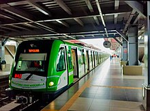
The line has an extension of 34.6 km (21.5 mi), with 26 stations, and goes from the south east to north east Lima urban districts passing downtown (This is Villa El Salvador to San Juan de Lurigancho).
The second line (called Linea 2) is now under construction and will run from the port of Callao to Ate passing downtown too (west to east).(2015).
Other important highways in Peru are the Longitudinal de la Sierra,[4] that goes from north to south in the highlands; and the Carretera Central, that goes from Lima (in the coast) to Pucallpa (in the jungle).
The main bus companies which link Lima with the major cities include Cruz del Sur and Ormeño.
Other companies are Civa and Oltursa.,[6] while the full list of carriers include Transported Libertad and Turismo Mer, among others.