Transportation in Calgary
The city of Calgary, Alberta, has a large transportation network that encompasses a variety of road, rail, air, public transit, and pedestrian infrastructure.
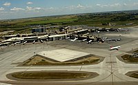
Calgary is also a major Canadian transportation centre and a central cargo hub for freight in and out of north-western North America.
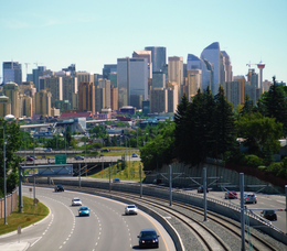
This outward growth has encouraged the development of an extensive personal vehicle-oriented road network complete with a freeway system.
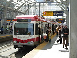
Since 1981, when the city officially opened the first leg of its CTrain rapid transit system, emphasis on public transportation as an alternative to cars has become important.
The CTrain has the second-highest light rail system ridership of any North American city, only slightly behind Guadalajara, Mexico.
In recent years, increases in the population and density of inner-city neighbourhoods such as the Beltline have favoured greater pedestrianism as well.
[3] Until very recently, Calgary and Edmonton were the only two North American cities with populations under two million to operate rapid mass transit systems.
[4] The extension of the Blue Line into west Calgary was completed in 2012 and is the most recent section of the network to open.
Plans originating in the 1950s and 1960s for a considerably more extensive freeway system including elevated freeways were largely abandoned in favour of a growing trend to reduce the emphasis on roads and increase the amount of public transportation infrastructure in North American cities.
They have the highest construction standards, speed limits of 100km/h and provided key connections to the rest of the provincial highway network.
A 100km long free flowing ring road that comply incircles Calgary and serves as a bypass for traffic wishing to avoid the core areas of the city.
Only the section between the Reconciliation Bridge and Deerfoot Trail is designated as a skeletal road with the rest of Memorial Drive being a slower moving Parkway.
The heavily signalized section of 16th Avenue through North-Central Calgary is designated as an Urban Boulevard and is never intended to be upgraded to a freeway.
This is because the city intends for eventually freeway removal on this section of Bow Trail as part of the West Village Redevelopment Plan.
Examples include Country Hills Boulevard, 17 Avenue (West Portion) and 69th Street W. Parkways, midsized 2 to 4 lane roads that are often near natural areas and seek to encourage green, high quality natural design such as large green buffers and are often closed to Truck Traffic.
Examples include the central portion of 16 Avenue N, of Centre Street and Macleod Trail near downtown.
Their purpose is to connect the major city roads to neighbourhoods and homes rather than facilitate longer distance travel.
Sidewalks at intersections in areas outside the downtown core are often stamped with the name of the cross-street, especially in older districts.
It is also a major hub for several cargo airlines including DHL, FedEx, Purolator, and United Parcel Service.
Calgary International airport also has regular scheduled service to London, Frankfurt, Amsterdam, Mexico City and Tokyo.
[11] On-It Regional Transit provides scheduled bus service to commuter towns surrounding Calgary.
The City of Calgary also maintains a network of paved multi-use pathways (for bicycling, roller skating and jogging).
The dedicated pathway network in Calgary is among the most expansive in North America and spans 900 km (560 mi).
In June 2013, massive flooding destroyed much of the pathway system (including many pedestrian bridges) along the Elbow and Bow rivers.