Tri-States Monument
In 1664, King Charles II of England granted his brother, James, the Duke of York, a Royal colony that covered what had been New Netherlands.
The western and northern border was to be:[8][9] along said River or Bay (the Delaware) to the northward as far as the northward most branch of the said Bay or River, which is in latitude 41 degrees, 40 minutes and crosseth over thence in a straight line to the latitude 41 degrees on Hudson's River: which said tract of land is hereafter to be called by the name of New Caeserea or New Jersey.In December 1872, the New Jersey Geological Survey had the State Geologist, George H. Cook, survey the boundary between New Jersey and New York.
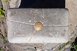
[10] In 1874, the United States Coast Survey recovered the previous crow foot cut marking the station location and placed a lead-filled copper pipe in a deep hole drilled into the bedrock.
[12] However, New York and Pennsylvania law describing the state boundary both explicitly refer to the monument as its eastern terminus.
[13][14] Since 1972, USGS maps reflecting the construction of Interstate 84, which crosses the two rivers just north of the monument, have shown the state lines meeting there.
It also lists the commissioners from New Jersey: Abraham Browning, Thomas N. McCarter, and George H. Cook; and surveyor Edward A. Bowser.
And lists the commissioners from New York: Henry R. Pierson, Chauncey M. Depew, Elias W. Leavenworth; and surveyor H. W.