Trinity River (California)
The river is known for its once prolific runs of anadromous fish, notably Chinook salmon and steelhead, which sustained Native American tribes for thousands of years.
During and after the gold rush, the influx of settlers and miners into the Trinity River country led to conflict with indigenous tribes, many of which saw severe depopulation due to fighting and foreign diseases.
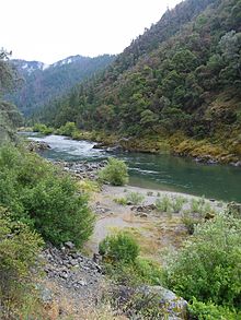
The Trinity River is an important water source for irrigation and hydroelectricity generation, as well as a major center of recreational activities such as gold panning, fishing and whitewater rafting.
[25] Extractive industries such as mining and logging, and to a limited extent farming and ranching, have been the main economic drivers in the Trinity River basin since European settlement in the 1800s.
[28] Rocks commonly found in the Trinity River area include gabbro, chert, granite, diorite, limestone, sandstone, serpentine, schist and marble.
[26] Gold-bearing quartz veins are widespread in local metamorphic rock formations; the richness of the area made it among the focal points of the California Gold Rush.
[27] The present shape of the mountains was highly influenced by underground volcanic activity, which created batholiths, domes of igneous rock formed by cooled magma.
[27] The higher mountains, including the Trinity Alps – the highest range in northwest California – were also sculpted by glaciation during successive Ice Ages, the last of which ended roughly 10,000 years ago.
[26][27] The Coast Ranges pass through the western part of the Trinity River Basin and consist of even younger rock formations, chiefly the Franciscan Assemblage.
[32] An archaeological site on the Trinity River at Cox Bar, with spear points dating from 3000–6000 BC, has some of the oldest evidence of human habitation in Northern California.
[33] Archaeological evidence in the Whiskeytown area also indicates human presence as early as 5000 BC, although it is uncertain at what point the ancestors of modern Native American tribes arrived here.
These initial meetings were peaceful, but the Wintu population – along with many other Central Valley tribes – were decimated by a malaria epidemic in the 1830s, accidentally introduced by Hudson's Bay Company fur trappers.
Weaverville, located at the end of the trail Reading had established from the Sacramento Valley to the Trinity, prospered as the main trade center through which gold was exchanged for imported supplies and services.
[50] Mining activity was initially concentrated in the eastern (upper) valleys of the Trinity River around Weaverville, as the hostile Native Americans and treacherous gorges around Burnt Ranch precluded the transport of rations and equipment to places further west.
Because hard rock mining was required to access the gold bearing veins, new industries such as iron forges and stamp mills prospered in the region.
At one point, there were 307 hydraulic mines in Trinity County alone, of which 145 were "fully operational", all of which depended on the use of pressurized water to demolish hillsides in search of gold bearing ore.[10] This had an enormous impact on the landscape – leveling forests, carving huge gullies and burying streambeds under dozens of feet of sediment – which still characterizes the area today.
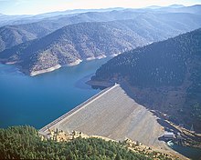
[51] After World War II commercial dredges continued to operate on the Trinity, but at a reduced scale, finally ending in 1959, when the last claim was bought by the federal government in preparation for dam construction of the Central Valley Project.
[48]: 15 Jorstad's cabin was an important rest stop for miners, hunters, hikers and fishermen along the North Fork for many years; it remains as a historical site maintained by the Forest Service.
[58][59] As early as the 1930s, the state of California had floated the idea of diverting water from the rainy north to support irrigation in the fertile, but dry San Joaquin Valley.
[68][69][70] Water flow data for the Judge Francis Carr hydroelectric station located at the end of Trinity Tunnel indicates an annual average of 1,257 cubic feet per second (35.6 m3/s), or 910,700 acre-feet (1.1233 km3), diverted from the river between 1963 and 2013.
Residents of the Trinity River valley were heavily opposed to the dam, but they had no recourse against eminent domain used by the federal government (although property owners were paid for their land).
The dam blocked salmon runs to 109 miles (175 km) of habitat in the upper Trinity River basin, destroying the fishing economy that had sustained local people for generations.
[72] Other residents welcomed the dam project for the economic benefits it would bring via hydropower and tourism, as the gold mining industry that had long supported the region was greatly diminished by the 1950s.
[21] The Shasta-Trinity National Forest encompasses nearly the entire Trinity River watershed with the exception of private inholdings and the small area in Humboldt County.
[31][80] Along the South Fork, this problem has been exacerbated by the inherently unstable rocks and soils of the Franciscan formation, causing mass wasting events that dump sediment into streams.
Most of it was used to develop new irrigation in the 600,000-acre (240,000 ha) Westlands Water District on the western side of the San Joaquin Valley,[82] which contains soils laced with salt and selenium.
[81] In the 1980s, water run-off from the Westlands district contributed to the highly publicized contamination of Kesterson Reservoir, part of the agricultural drainage system and a significant refuge for birds and wildlife.
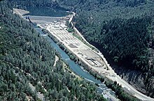
[83] After the completion of Lewiston Dam in 1963, the Bureau of Reclamation constructed the Trinity River Fish Hatchery to raise young steelhead, coho and chinook salmon.
Bulldozing of the riverbanks to clear space for juvenile salmon habitat has harmed steelhead spawning grounds, impacted public access and allowed the spread of invasive plant species.
[94]: 111–116 The California Office of Environmental Health Hazard Assessment (OEHHA) has developed a safe eating advisory for fish caught in the Trinity River based on levels of mercury or PCBs found in local species.