Tropical Storm Laura (1971)
Initially, Laura was forecast to move across the island and impact the southern United States, but it executed a small loop and turned to the southwest.
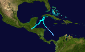
Receiving the name Laura, the storm continued to intensify as it turned northward toward western Cuba; late on November 15, it attained peak winds of 70 mph (110 km/h).
Although a cold front was expected to bring the storm to the north, a ridge instead increased over the southeastern United States, which prevented Laura from moving ashore.
Late on November 20, Laura again reached peak winds of 70 mph (110 km/h), which was maintained for 30 hours until the storm made landfall in Punta Gorda, Belize.
[5] The highest total in the country was 32.5 inches (83 cm), and overall the storm impacted four provinces, including Isle of Youth, Pinar del Río, La Habana, and the city of Havana.
Due to the flooding, officials forced 26,000 people from their homes in Pinar del Río, and one person in that province drowned while crossing a river.
Tropical storm (39–73 mph, 63–118 km/h)
Category 1 (74–95 mph, 119–153 km/h)
Category 2 (96–110 mph, 154–177 km/h)
Category 3 (111–129 mph, 178–208 km/h)
Category 4 (130–156 mph, 209–251 km/h)
Category 5 (≥157 mph, ≥252 km/h)
Unknown