Tropical Storm Leslie (2000)
The twelfth named storm of the season, Leslie formed on October 4 over eastern Florida as a subtropical cyclone, out of a trough of low pressure.
The wave traversed around the periphery of Hurricane Keith, and by October 2, the system produced a mid-level circulation just south of western Cuba.
The tropical wave interacted with an approaching frontal trough, while its mid-level center turned to the northeast and made landfall near Sarasota, Florida on October 4.
[1] The National Hurricane Center initially forecast further intensification to 60 mph (95 km/h),[3] although the agency also noted that the circulation could dissipate, due its fast forward motion toward the east-northeast.
The remnants of Leslie turned to the east, then southeast, strengthening to near-hurricane-force winds before losing its identity near Ireland on October 10.
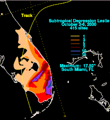
[1] The National Hurricane Center predicted the trough of low pressure to drop very heavy rainfall across western Cuba and Florida.
[7] While Leslie was moving east-northeastward, it posed a threat to Bermuda, prompting officials to issue a tropical storm watch at 0300 UTC on October 6.
[1] The precursor disturbance of Leslie dropped heavy rainfall across central and western Cuba, peaking at 8.25 in (210 mm) in the province of Havana.
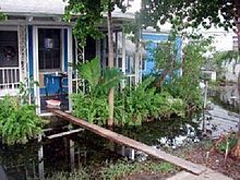
[13] The flood waters, which were four ft (1.2 m) deep in places, stranded many in their houses, forcing them to use canoes or inflatable rafts to move to higher grounds.
[10] The flooding indirectly killed three people, two from drowning as a result of driving vehicles into deep water,[1] and one when a man fell from a tall building while trying to unclog a roof drain.
[15] The U.S. Department of Agriculture declared 16 Florida counties, including Miami-Dade, Collier, and Palm Beach, as primary disaster areas due to flooding, making farmers and their families there eligible for USDA emergency farm loans.
[18] In addition, Miami-Dade and Broward Counties were declared eligible for Federal Infrastructure Assistance, which provided for 75% of the debris removal cost and the repairing or replacement of public roads, buildings, parks, and treatment plants.
[19] By ten days after the storm, government agencies distributed 105,000 meals, 141,000 US gal (530,000 L) of water, and 357,000 lb (162,000 kg) of ice.

Tropical storm (39–73 mph, 63–118 km/h)
Category 1 (74–95 mph, 119–153 km/h)
Category 2 (96–110 mph, 154–177 km/h)
Category 3 (111–129 mph, 178–208 km/h)
Category 4 (130–156 mph, 209–251 km/h)
Category 5 (≥157 mph, ≥252 km/h)
Unknown