Tropical cyclones in 2022
[4] The season started on May 31, when a low pressure area formed near the Yucatán Peninsula, partially related to the Pacific basin as the remnants of Agatha.
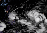
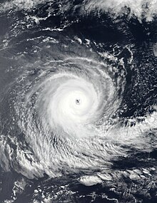
On June 23, a tropical wave that originated from the coast of Africa producing a large but disorganized area of showers and thunderstorms and the NHC classified the system as Invest 94L.
Julia then left the Atlantic basin and entered the Eastern Pacific as a tropical storm before becoming a remnant low offshore of Guatemala on October 10.
On November 4, the NHC began to monitor an area in the northeastern Caribbean Sea where a large non-tropical low pressure system was expected to develop within a few days.
Despite Nicole being relatively weak, its large size caused heavy damage across its path including parts of Florida which was already devastated by Hurricane Ian six weeks earlier.
Agatha reached its peak intensity as a Category 2 hurricane and made landfall near Puerto Angel in Mexico with winds up to 105 mph.
Additionally, six people died in El Salvador due to heavy rain related to Blas's precursor disturbance and other weather systems.
Followed by Invest 97E, the NHC began monitoring another low pressure area which was located southwest of the coast of southwestern Mexico for possible tropical development on July 25.
Georgette stayed as a tropical storm during its lifespan and failed to strengthen any further due to heavy wind shear generated by the outflow from the circulation of nearby Hurricane Frank.
On August 2, the NHC began monitoring a tropical wave producing widespread showers and thunderstorms over Central America and the adjacent waters in anticipation that an area of low pressure would form once it moved over the eastern Pacific.
Additionally, Kay's outer bands struck Southern California which brought heavy winds and record rainfall mostly in San Diego County.
The Western Pacific Ocean typhoon season began on March 29, with the formation of a tropical depression southeast of Da Nang, Vietnam.
The storm then made landfall near Busan in South Korea and the JMA declared Hinnamnor as an extratropical low as it was located in the Sea of Japan.
As the typhoon approached the coast of China, Nalgae weakened back into a tropical storm and made its final landfall over Xiangzhou District, Zhuhai.
Pakhar's close approach to the Bicol Region and Polillo, Quezon prompted the PAGASA to raise Tropical Cyclone Warning Signal (TCWS) #1 in some areas in Southern Luzon.
Pakhar then intensified further, but later rapidly weakening and dissipating by December 12 from high vertical wind shear and dry air sent by the northeast monsoon, making its circulation exposed.
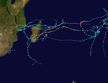
By the end of February, Tropical Depression 08 from the South-West Indian Ocean basin briefly moved westward while undergoing a Fujiwara interaction with Vernon.
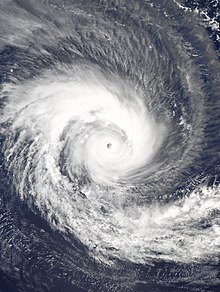
Dovi then intensified into its peak strength as a Category 4 severe tropical cyclone, before making landfall on New Zealand, causing minor flooding.
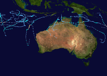
Gina reached its peak intensity as a Category 1 cyclone on the Australian scale before weakening due to high wind shear which deteriorated its structure.
[10] It transitioned into a subtropical storm at around 03:00 UTC on December 30, however the agency gave the system a low chance to develop into tropical cyclone due to persistent unfavorable environment.
The Western Pacific Ocean typhoon season began on March 29, with the formation of a tropical depression southeast of Da Nang, Vietnam which received the designation 01W by the JTWC.
As it approached the coast of India, Asani began to stall and started losing its strength due to severe wind shear and dry air.
The Atlantic basin featured, Bonnie which formed off the Caribbean coast of Central America on July 1 and made landfall near the Costa Rica–Nicaragua border on the next day.
In the North Atlantic, Tropical Storms Gaston and Hermine as well as Hurricanes Danielle, Earl, Fiona, and Ian and a depression classified as Eleven formed after a 60-day lull in activity within the basin.
The Western Pacific basin saw the formations of Tropical Storms Talas and Kulap, Typhoons Muifa, Merbok, Nanmadol, Noru, and Roke and a short lived depression.
Julia killed at least 91 people across Central America and Venezuela before emerging into the Pacific Ocean; becoming the second storm of the season to survive the crossover, after Bonnie in July.
In the Western Pacific basin, Tropical Storms Sonca, Haitang, Nalgae, Banyan, Typhoon Nesat, along with three short lived depressions formed.
Nesat travelled across the South China Sea, reaching its peak intensity as a Category 2 typhoon before dissipating between Vietnam and Hainan Island.
Despite Nicole being relatively weak, its large size inflicted severe damage to many areas including Florida, which was already devastated by Ian six weeks earlier.
In the Southern Hemisphere, two tropical lows classified as 02U and 03U formed in the Australian region with 02U crossing over to the South-West Indian Ocean basin where it was re-classified as 03 before dissipating.