Tualatin River
[6] The Tualatin River arises near Windy Point on the eastern side of the Northern Oregon Coast Range.
From the unincorporated community of Cherry Grove, 68 miles (109 km) from the mouth, the river falls only about 220 feet (67 m) in meanders that trend generally east across the relatively flat Tualatin Valley.
Thereafter, it flows under Northwest Mount Richmond Road and receives Mercer Creek from the left about 65 miles (105 km) from the river's mouth.
Below this, Black Jack Creek enters from the left, and the river passes under Oregon Route 47 and flows by the city of Gaston, which is to the right.
[7][8] Turning north near Gaston and meandering roughly parallel to Route 47 to the west (left), the river receives Wapato Creek, which flows through the former Wapato Lake, from the right and Scoggins Creek, which drains Henry Hagg Lake, from the left at RM 60 (RK 97).
Further downstream, it receives Christensen and Burris creeks from the right and continues south until turning east again at about RM 30 (RK 48).
Leaving the wildlife refuge about 4 miles (6 km) later, the rivers meanders around the unincorporated community of Bull Mountain, which is on its left (north), passes under Roy Rogers Road, receives Chicken Creek and Rock Creek from the right, then passes under Oregon Route 99W (Southwest Pacific Highway) at King City.
The stream passes under another Portland & Western Railroad bridge, then under Southwest Boones Ferry Road and then under Interstate 5, the latter at about RM 8 (RK 13), and enters Clackamas County.
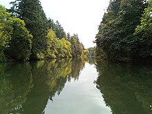
It flows by Swift Shore Park, which is on the left, under Southwest Pete's Mountain Road, by Willamette Park, also on the left, and enters the Willamette River at West Linn, about 28 miles (45 km) from the larger river's confluence with the Columbia River.the mouth is five miles away from oswego lake.
[7][8] The highest flow ever recorded in the river was 26,400 cubic feet per second (750 m3/s) on February 10, 1996, at the West Linn gage.
The drainage area of the river is approximately 712 square miles (1,840 km2) with 27 creeks feeding into the Tualatin.