Tulul adh-Dhahab
[4] The double hills (hence the plural 'Tulūl', proper: dual 'Tellan' rather than the singular 'Tell') are situated in the Zarqa River valley at the opening of the southern Wadi Hajjaj.
Ancient hikers had to dodge the way into the Zarqa valley and head to the Wadi Hajjaj, the shortest way to settlement area of the Ammonites.
That is the reason why the Tulul adh-Dhahab had, until the construction of the Roman road at the exit of Wadi az-Zarqa in Jordan Valley near the present village of Abu Zighan, a high strategic importance.
[5] 6.5 kilometers west of the Tulul adh-Dhahab there is the large Tell of Deir Alla, dating to the Bronze and Iron Age, commonly identified with the biblical city of Sukkot.
[3] Based on the Genesis account, scholars believed Penuel to be the location of a sacred sanctuary,[6] and presumed that there must have been a temple from Iron Age I or earlier on one of the peaks.
[1] Scholars of the Hellenistic period proposed to identify the site with the Seleucid cities of Amathous and Essa mentioned in the writings of Flavius Josephus.
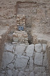
Since 2005, annual excavations are conducted in the western hill by a team from the University of Dortmund, under the direction of Prof. Dr. Thomas Pola, in collaboration with the Jordanian Department of Antiquities.
They are engaged in the geomagnetic prospection, the tachymetric 3D surveying and the production of close-range aerial photographs for photogrammetric purposes[9] of the site.
In addition to the work of R. L. Gordon in 1980/82, there is now for the first time a detailed map of the entire excavation site available in which all the visible surface artifacts are measured.On the two highest terraces of the hill so far three settlement phases were detected archaeologically:
The fragments of architecture of this palace are stylistically placed in the late Hellenistic period or during the early years of Herod the Great (73-4 BCE), coins and 14C data corroborate this time approach.
The top two terraces on the steep eastern and south slope were surrounded by a today about 0.5 - 1.5m high preserved wall, its original height is not known.
[7] Furthermore, a Chalcolithic settlement lies at the southeastern foot of the western mound, Tell edh-Dhahab el-Gharbi, only slightly above the Jabbok River, but safely above the flood line.