Tunica people
The archaeological evidence suggests that the Mississippi valley was home to several competing paramount chiefdoms, with supporting vassal states, all belonging to the same overall culture.
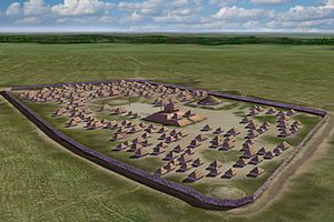
The large village was likely located at the confluence of the two rivers because the site enabled residents to control transportation and trade on the waterways.
Scholars believe that because of pottery and mortuary similarities, the Belle Mead and Walls phase peoples were allies or vassals of the Nodena polity.
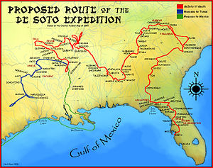
We took more than three hundred women, and the few skins and shawls they had in their houses.In the spring of 1541 Hernando de Soto and his army approached the eastern bank of the Mississippi River, coming upon the Province of Quizquiz (pronounced "keys-keys").
Only by means of two stairways could one ascend to this house…… The lord of the province, who like his land was called Quizquiz, was now old and sick in bed; but on hearing the noise and confusion in his village, he arose and came from his bedchamber.
Archaeologists believe the location for the Province of Coligua may be the Greenbriar phase on the White River at the edge of the Ozark Highlands.
Europeans also called the settlement Tanico, which is another name later applied to the Tunica, also making its identification as a Tunican group secure.
[5] Scholars have evaluated the three surviving Soto narratives for topography, linguistics and cultural traits, combined with the results of archaeological excavations and analysis.
[12] The description of the ongoing war between the Casqui and Pacaha matches interpretations of the archaeological record, as do distances and topography mentioned in the narratives.
Words recorded by the narratives at Pacaha, such as mochila, macanoche, and caloosa, match Tunica linguistic characteristics evaluated by Mary Haas in the 1940s.
It is now theorized that the peoples of the Central Mississippi Valley, from Pacaha in the north to the Provinces of Anilco and Utiangüe in the south on the Arkansas River, were all Tunican.
In 1699 when encountered by the LaSource expedition (coming downriver from Canada), the Tunica were a modest-sized tribe numbering only a few hundred warriors, with about 900 people in total.
[5] By the time the French arrived, the Central Mississippi Valley was sparsely occupied by the Quapaw, a Dhegiha Siouan-speaking people hostile to the Tunica.
In the intervening century and a half since the de Soto Expedition, the Tunica and Koroa had relocated further south to the mouth of the Yazoo River in west central Mississippi.
In November 1729 the French commander Sieur de Chépart ordered the Natchez to vacate one of their villages so that he could use its land for a new tobacco plantation.
The young Great Sun and about 100 of his followers were captured, subsequently enslaved, and shipped to work French plantations in the Caribbean.
[20] In June 1730 the Head Chief of the Tunica, Cahura-Joligo, agreed to let a small party of Natchez refugees settle near his village, with the provision that they should do so unarmed.
A few days later, the last chief of the Natchez arrived at the Tunica village with a hundred men, and an unknown number of women and children.
His war-chief Brides les Boeufs (Buffalo Tamer), with a dozen of his warriors, repulsed the attack and retook the Head Chief's cabin.
[17] After the attack and plundering of their village at Angola, in 1731 the Tunica moved a few miles away to the Trudeau site in West Feliciana Parish.
He has learned of us to hoard up money, and he reckoned very rich.Because of the expense of shipping horses from France, the French found it cheaper to buy them in La Louisiane from the Tunica.
What has been called the "Trudeau Treasure" was the greatest amount of European trade goods found at any Native American site of this period.
[25] In 1764, the Tunica moved fifteen miles (24 km) south of the Trudeau Landing site to just outside the French settlement at Pointe Coupée.
[citation needed] With the British in charge of the Western Florida colony east of the Mississippi River, and the Spanish in control of Louisiana, it was a volatile time politically for the area.
In 1794 a Sephardic Jewish immigrant from Venice, Italy, named Marco Litche (the French recorded him as Marc Eliche), established a trading post in the area.
By the late 19th century, railroads surpassed the rivers as the main means of transportation, and the Marksville area became a quiet backwater.
The man, a local leader of the "Indian Patrol", shot Chief Melancon in the head in full view of other Tunica.
In the 1960s a treasure hunter named Leonard Charrier began searching for artifacts at the Trudeau Landing site in West Feliciana Parish, Louisiana.
It helped to lay the groundwork for new federal legislation, the Native American Graves Protection and Repatriation Act, passed in 1990.
Members of the tribe were trained as conservators to repair damage by the centuries underground, and storage and handling during the ten-year court battle.