Tyldesley
At the United Kingdom Census 2001, the Tyldesley built-up area subdivision, excluding Shakerley, had a population of 16,142.
[1] The remains of a Roman road passing through the township on its ancient course between Coccium (Wigan) and Mamucium (Manchester) were evident during the 19th century.
[4] The factory system and textile manufacture during the Industrial Revolution triggered population growth and urbanisation, and by the early 20th century it was said that the mill town was "eminently characteristic of an industrial district whose natural features have been almost entirely swept away to give place to factories, iron foundries, and collieries".
The old name for Mosley Common was the "Hurst" or "Tyldesleyhurst"; the suffix "hyrst" means a wooded hill (OE).
[7] The remains of a Roman road serving camps at Coccium (Wigan) and Mamucium (Manchester) passed through the area.
Evidence for the presence of Saxons is provided by place names incorporating the Old English suffix leah, such as Tyldesley,[6] Shakerley, and Astley.
In medieval times they paid rent to Cockersand Abbey and dues of "one pair of white gloves at the feast of Easter" to Adam Tyldesley.
[22] Cleworth Hall, recorded as Cluworth in 1333, was part of the Tyldesley lands on higher ground north of the high road.
A well-known "conjurer" or wise man, Edmund Hartley, was asked to cure them, which he apparently did before demanding money which was refused.
[24] In the early 18th century Tyldesley was a collection of cottages and farms around the halls scattered across the township with no church or inn.
Thomas Johnson, a Bolton merchant bought the Banks Estate in 1728, land from the Stanleys of Garrett Hall in 1742 and Davenports in the west of the township in 1752.
The last quarter of the 18th century marked the beginning of a building boom and the grid plan of the town centre is from this date.
[26] John Aikin described the area in 1795 in his book A Description of the Countryside from 30 to 40 Miles around Manchester: The Banks of Tildesley, in the Parish of Leigh, are about one mile and a half in length, and command a most beautiful prospect into seven counties: the springs remarkably clear and most excellently adapted to the purposes of bleaching.
Until the Industrial Revolution, Tyldesley was rural, agriculture and cottage spinning and weaving, mainly muslin and fustian,[30] were the chief occupations before 1800.
More cotton mills were built close to the Hindsford and Shakerley Brooks which provided water for steam power.
In 1823, after a strike for increased wages and lockout by the millowners at New Mills, owned by J & G Jones in Factory Street, the workforce was sacked and new hands hired to replace them.
Barnfield No 6 was a concrete-floored multi-storey mill for spinning, powered by an external engine house via a rope race.
The worst mining disaster in the town occurred at Yew Tree Colliery on 11 December 1858 when an explosion of firedamp caused by a safety lamp cost 25 lives.
Historically, Tyldesley formed part of the Hundred of West Derby, a judicial division of southwest Lancashire.
The banks, a sandstone escarpment with the scarp slope facing south and the gentler dip to the north, are about one and a half miles long.
[5] Heavily industrialised during the 19th century, Tyldesley has become a residential area since the demise of the coal industry and closure of its cotton mills.
[75] According to the United Kingdom Census 2001, the industry of employment of residents aged 16–74 was 18.1% retail and wholesale, 16.5% manufacturing, 12.1% property and business services, 10.9% health and social work, 7.4% education, 7.1% transport and communications, 7.6% construction, 5.8% public administration, 5.0% finance, 4.1% hotels and restaurants, 0.8% energy and water supply, 0.5% agriculture, 0.1% mining, and 4.2% other.
Since the closure of the mines and demolition of the factories, St George's Church—one of the few structures in the town built of stone, with a spire rising to 150 feet (46 m) in height—and Top Chapel in the Market Square have become the chief landmarks; both are Grade II listed buildings.
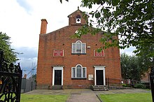
Tyldesley's first place of worship, Top Chapel was built in the Square in 1789 for the Countess of Huntingdon's Connexion which had broken from the Church of England.
Thomas Johnson, gifted the site on the highest point of Tyldesley and Lady Huntingdon, a supporter of Wesley supplied money for building materials.
Robert Smirke an official architect to the Office of Works, advised the Parliamentary Commissioners on the building of new churches from 1818 onwards, including St George's.
Two members of Tyldesley Swimming and Water Polo Club represented Great Britain in Olympic Games.
[114] Long-distance runner Fred Norris worked underground at Cleworth Hall Colliery and competed in the 1952 Helsinki and 1956 Melbourne Olympics.
[115] Tyldesley's wealth as an industrial town resulted in outlets for the entertainment of its population, including cinemas and public houses.
[121] Tyldesley Little Theatre in Lemon Street is home to an amateur dramatic society, members of the Greater Manchester Drama Federation.