Typhoon Durian
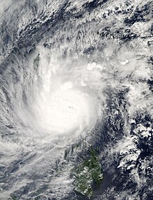
Durian first made landfall in the Philippines, packing strong winds and heavy rains that caused mudflows near Mayon Volcano.
[7][nb 2] On November 27, the JTWC noted that Durian could undergo explosive intensification as it moved over the Philippine Sea two days later, similar to what took place with Typhoons Cimaron and Chebi.
[9] On November 28, the Philippine Atmospheric, Geophysical and Astronomical Services Administration assigned the storm the local name Reming as it entered their area of responsibility.
[10] Durain attained its peak intensity late on November 29 just off the coast of the Philippines with winds of 195 km/h (121 mph) and a barometric pressure of 915 millibars (915 hPa; 27.0 inHg).
[6] By the end of the rapid intensification phase, Durian turned nearly due west as a subtropical ridge built to its north.
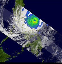
Passing over the Isla Verde Passage, Durian emerged into the South China Sea early on December 1 as a minimal typhoon.
[14] Gradual re-intensification occurred over the subsequent days, with the storm attaining a secondary peak strength of 150 km/h (93 mph) early on December 3.
[6] Ultimately, Durian made its fourth overall landfall early on December 5 over the Mekong Delta south of Ho Chi Minh City with winds of 85 km/h (53 mph).
[7] Within hours of moving onshore, a combination of land interaction and poor upper-level outflow caused all deep convection to dissipate.
Environmental conditions were marginally favorable for development;[16] however, Durian failed to reorganize further and degenerated into a remnant low late on December 7 as it moved just south of the Andaman Islands.
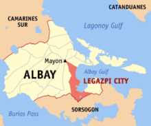
[6] The Bicol region, where Durian first struck, is located at the southeastern portion of the Philippine island of Luzon, and is affected by an average of 8.4 tropical cyclones per year.
[18] The Philippines' National Disaster Coordinating Council issued severe weather bulletins and advisories,[20] and overall, 25 provinces in the archipelago were placed on storm alert.
[21] The threat of the typhoon caused ferry, bus, and airline services to be canceled,[18] stranding thousands of people for several days.
These areas, as well as the inland provinces of Đắk Lắk, Lâm Đồng, and Bình Phước redirected all focus on the typhoon and the potential for life-threatening flash flooding.
In the mountainous region, a process known as orographic lift produced heavier rainfall than near the coast, with totals possibly as high as 600 mm (24 in).
[56] On December 3, Philippine President Gloria Macapagal Arroyo declared a state of national calamity, due to the successive impacts of typhoons Xangsane, Cimaron, and Durian.
[20] Arroyo ordered the immediate release of 1 billion Philippine pesos ($20.7 million, 2006 USD) for relief in areas affected by typhoons Durian, Xangsane, and Cimaron.
[59] Soon after Durian exited the country, workers began restoring power lines and clearing debris and trees from roads,[23] which was required before relief agencies reached the hardest hit areas.
[63][64] Various companies and local organizations donated to the relief effort, such as medicine, food, water, transport supplies, clothes, and money.
[66] Indonesia sent two C-130 Hercules aircraft to Legazpi City, carrying a total of 25 tons of food, medicine, and clothing valued at 1.17 billion Indonesian rupiah (US$129,000).
In March 2009, the agency completed the missions responding to the 2006 storms and transferred the remaining funds to help repair from Typhoon Fengshen in 2008.
[52] The Tzu Chi Foundation set up a temporary medical camp in Tabaco to provide free health care to storm victims.
[72] Beginning in January 2007, the United Nations Food and Agriculture Organization distributed about 150 packs of vegetable seeds and farm tools to displaced residents in three Bicol provinces, as part of the sustainable recovery program planned by the Philippine government for storm victims.
[52] After the successive impacts of Xangsane and Durian caused widespread power outages, the Bicol region lost about $250 million in economic output.
A fleet of over 200 vehicles transported relief supplies – food, construction materials, clothing, and medicine – to the Bicol region on December 12.
The Department of Health also distributed tents and sleeping bags, provided vaccines to people in evacuation camps, and ensured proper burial of storm casualties.
[41] Many of the storm victims left homeless resided in tent camps, schools, and temporary shelters, until more permanent buildings were built.
[20] In 2011, the Regional Development Council approved a budget to construct additional dams along the Mayon Volcano to prevent the deadly floods and landslides that occurred during Durian.
[86] The 39th session of the United Nations Economic and Social Commission for Asia and the Pacific/World Meteorological Organization's Typhoon Committee met in Manila, Philippines from December 4–9, soon after the onslaught of the floods from Durian.
The committee's regional director stated in their report, "I wish to extend WMO’s sincere condolences and sympathy to your Government and to the Philippine people who were adversely affected by the past typhoons."

Tropical storm (39–73 mph, 63–118 km/h)
Category 1 (74–95 mph, 119–153 km/h)
Category 2 (96–110 mph, 154–177 km/h)
Category 3 (111–129 mph, 178–208 km/h)
Category 4 (130–156 mph, 209–251 km/h)
Category 5 (≥157 mph, ≥252 km/h)
Unknown