Typhoon Tembin
Unfavorable conditions enhanced by the winter monsoon caused Tembin to rapidly weaken shortly afterwards, before it ultimately dissipated on December 26 while just south of Vietnam.
[6][7] During December 16, the Japan Meteorological Agency (JMA) classified the disturbance as a weak tropical depression, however they reclassified it as an area of low pressure during the following day.
[8][9][10] During December 20, the JMA reclassified the system as a tropical depression, after atmospheric convection had started to wrap into the low-level circulation center (LLCC).
[11][12] By this time the system was located about 85 km (55 mi) to the northwest of Melekeok, Palau, and moving northwestwards along the subtropical ridge towards Mindanao in the Philippines.
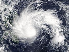
[13][16][17] On December 21, satellite imagery revealed formative banding wrapping around Tembin's LLCC amid an environment of low to moderate vertical wind shear and warm waters of 29 °C (84 °F).
[21] Within the JTWC's next advisory on 21:00 UTC, they mentioned that feeder bands was wrapping in a central dense overcast feature that was obscuring its LLCC.
[30] It was forecast that the storm would bring gusty winds ranging from 95 to 140 km/h (59 to 87 mph) over Mindanao, and both Palawan and northern Sabah were warned to have an estimated rainfall of 125–500 mm (4.9–19.7 in), increasing the risk of mudslides and flash floods.
[34] The Cebu City Disaster Risk Reduction Management Office (CCDRMO) also advised the public to delay their trips to the south and let the storm pass through before leaving their homes.
[35] About 28 vessels were not allowed to sail in some Cebu ports, which were bound for Bohol, Negros Occidental, Leyte and Mindanao, despite the area was not listed under a storm signal warning.
[39] Rough seas were observed off Quezon Province, which resulted in an accident where a ferry carrying about 250 passengers sank off Infanta, killing five people.
[40] On December 24, Vietnamese Prime Minister Nguyễn Xuân Phúc instructed the southern provinces to focus on preparing for the coming storm.
[47] A spokesperson from the NDRRMC had stated that the unusual high death toll was "unacceptable" although the government had properly provided information and prepared early for the storm.
Due to the damage and high death toll in Mindanao, the name Tembin was officially retired during the 50th annual session of the ESCAP/WMO Typhoon Committee in February 2018.

Tropical storm (39–73 mph, 63–118 km/h)
Category 1 (74–95 mph, 119–153 km/h)
Category 2 (96–110 mph, 154–177 km/h)
Category 3 (111–129 mph, 178–208 km/h)
Category 4 (130–156 mph, 209–251 km/h)
Category 5 (≥157 mph, ≥252 km/h)
Unknown