United States Coast and Geodetic Survey
It was not until 1811 that Jefferson's successor, President James Madison, sent Hassler to Europe to purchase the instruments necessary to conduct the planned survey, as well as standardized weights and measures.
Hassler believed that expertise in coastal surveys would be of importance in future wars and welcomed the participation of Army and Navy personnel, and his vision in this regard laid the foundation for the commissioned corps of officers that would be created in the Survey in 1917 as the ancestor of today's National Oceanic and Atmospheric Administration Commissioned Corps.
Various superintendents developed its work in fields as diverse as astronomy, cartography, meteorology, geodesy, geology, geophysics, hydrography, navigation, oceanography, exploration, pilotage, tides, and topography.
The Survey published important articles by Charles Sanders Peirce on the design of experiments and on a criterion for the statistical treatment of outliers.
[10] Gedney was in command of the Revenue-Marine revenue cutter USRC Washington on August 26, 1839, when she discovered and seized the Spanish schooner La Amistad off Culloden Point on Long Island, New York.
[13][14][15] In 1838, U.S. Navy Lieutenant George M. Bache, while attached to the Survey, suggested standardizing the markings of buoys and navigational markers ashore by painting those on the right when entering a harbor red and those on the left black; instituted by Lieutenant Commander John R. Goldsborough in 1847, the "red right return" system of markings has been in use in the United States ever since.
[2] Bache also instituted regular and systematic observations of the tides and investigated magnetic forces and directions, making the Survey the center of U.S. government expertise in geophysics for the following century.
In the late 1840s, the Survey pioneered the use of the telegraph to provide highly accurate determinations of longitude; known as the "American Method," it soon was emulated worldwide.
[20] Ever since it began operations, the Coast Survey had faced hostility from politicians who believed that it should complete its work and be abolished as a means of reducing U.S. government expenditures, and Hassler and Bache had fought back periodic attempts to cut its funding.
[7] On June 21, 1860, the greatest loss of life in a single incident in the history of NOAA and its ancestor agencies occurred when a commercial schooner collided with the Coast Survey paddle steamer Robert J. Walker in the Atlantic Ocean off New Jersey.
Civilian Coast Surveyors were called upon to serve in the field and provide mapping, hydrographic, and engineering expertise for Union forces.
The U.S. Congress specifically appropriated funding for such work in the 1875–1876 budget under which the 76-foot (23-meter) schooner Drift was constructed and sent out under U.S. Navy Acting Master and Coast Survey Assistant Robert Platt to the Gulf of Maine to anchor in depths of up to 140 fathoms (840 feet; 256 meters) to measure currents.
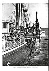
It was in connection with intensive studies of the Gulf Stream that the Coast and Geodetic Survey ship USC&GS George S. Blake became such a pioneer in oceanography that she is one of only two U.S. ships with her name inscribed in the façade of the Oceanographic Museum (Musée Océanographique) in Monaco due to her being "the most innovative oceanographic vessel of the Nineteenth Century" with development of deep ocean exploration through introduction of steel cable for sounding, dredging and deep anchoring and data collection for the "first truly modern bathymetric map of a deep sea area.
"[28] By the mid-1880s, the Coast and Geodetic Survey had been caught up in the increased scrutiny of U.S. government agencies by politicians seeking to reform governmental affairs by curbing the spoils system and patronage common among office holders of the time.
The commission looked into three main issues: the role of geodesy in the U.S. government's scientific efforts and whether responsibility for inland geodetics should reside in the U.S. Coast and Geodetic Survey or the U.S. Geological Survey; whether the Coast and Geodetic Survey should be removed from the Department of the Treasury and placed under the control of the Department of the Navy, as it had been previously from 1834 to 1836; and whether weather services should reside in a military organization or in the civilian part of the government, raising the broader issue of whether U.S. government scientific agencies of all kinds should be under military or civilian control.
Chenoweth found that the Coast and Geodetic Survey had failed to account for government equipment it had purchased, continued to pay retired personnel as a way of giving them a pension even though the law did not provide for a pension system, paid employees whether they worked or not, and misused per diem money intended for the expenses of personnel in the field by paying per diem funds to employees who were not in the field as a way of augmenting their very low authorized wages and providing them with fair compensation.
[30] To address issues at the Coast and Geodetic Survey raised by the Allison Commission and the Chenoweth investigation, Cleveland made the Chief Clerk of the Internal Revenue Bureau, Frank Manly Thorn, Acting Superintendent of the Coast and Geodetic Survey on July 23, 1885, and appointed him as the permanent superintendent on September 1.
Ignorant of the Survey's operations and the scientific methods that lay behind them, he left such matters to his assistant, Benjamin J. Colonna, and focused instead on reforming the Survey's financial and budgetary procedures and improving its operations so as to demonstrate the value of its scientific program in performing accurate mapping while setting and meeting production deadlines for maps and charts.
[34] Another victory followed in 1887, when Thorn headed off a congressional attempt to subordinate the Survey to the Navy despite the Allison Commission's findings, providing Cleveland with information on the previous lack of success of such an arrangement.
[9] By a resolution of April 12, 1892, Congress granted the use of the facilities of the Coast and Geodetic Survey for research and study by scientific investigators and students of any institution of higher education.
[38] On April 5, 1893, Survey Superintendent Thomas Corwin Mendenhall, with the approval of United States Secretary of the Treasury John Griffin Carlisle, formally issued the Mendenhall Order, which required the Office of Weights and Measures to change the fundamental standards of length and mass of the United States from the customary English system to the metric system.
"[44] In 1904, the Coast and Geodetic Survey introduced the wire-drag technique into hydrography, in which a wire attached to two ships or boats and set at a certain depth by a system of weights and buoys was dragged between two points.
[42] The Air Commerce Act, which went into effect on May 20, 1926, among other things directed that the airways of the United States be charted for the first time and assigned this mission to the Coast and Geodetic Survey.
From 1934 to 1937, it organized surveying parties and field offices to employ over 10,000 people, including many unemployed engineers, during the height of the Great Depression.
Coast and Geodetic Survey civilians who remained in the United States during the war produced over 100 million maps and charts for the Allied forces.
During the IGY, 67 countries cooperated in a worldwide effort to collect, share, and study data on eleven Earth sciences – aurora and airglow, cosmic rays, geomagnetism, gravity, ionospheric physics, longitude and latitude determinations for precision mapping, meteorology, oceanography, seismology, and solar activity.
[50] On July 13, 1965, the Environmental Science Services Administration (ESSA), was established within the Department of Commerce and became the new parent organization of both the Coast and Geodetic Survey and the United States Weather Bureau.
[1][26] Via a phased process during 1972 and 1973, the ships of the NOS joined ships temporarily assigned to NOAA's National Marine Fisheries Service or the Environmental Research Laboratories in forming a consolidated and unified NOAA fleet, operated by the National Ocean Survey's Office of Fleet Operations.
During the Mexican War (1846–1848), the brig USRC Washington, a revenue cutter on loan from the U.S. Revenue-Marine, became the first Coast Survey ship to see U.S. Navy service.
When the Environmental Science Services Administration (ESSA) was created in 1965, the Coast and Geodetic Survey came under its control but retained its distinct identity, continuing to operate its own fleet.