U.S. Route 191 in Arizona
With a total length of 516.50 miles (831.23 kilometres), the section of U.S. Route 191 (US 191) through Arizona has the longest distance of any numbered highway within the state.
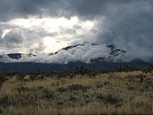
Large sections of the serpentine route taken by US 191 are indirect and include switchbacks in the mountainous regions near Alpine.
[1] The national southern terminus of US 191 is located at an intersection with SR 80 west of Douglas, in Cochise County.
[5] It heads north from this junction, past Bisbee Douglas International Airport and then through the unincorporated communities of McNeal and Elfrida before passing by Sunizona and the western terminus of SR 181, which provides access to Chiricahua National Monument.
The road curves west and heads toward Sunsites, where it turns to the northwest and passes by the community of Cochise with a bridge over the Union Pacific Railroad.
[4] Continuing northwest, US 191 meets Interstate 10 at Exit 331, a trumpet interchange, and has a concurrency with I-10 for about 21 miles (34 kilometres).
Going toward Safford, the eastern terminus of two state routes intersect the route, namely SR 266, which provides access to Fort Grant, and SR 366 in Swift Trail Junction, which climbs up to the summit of Mount Graham and provides access to Mount Graham International Observatory.
[5] Traveling east from Safford, US 70/US 191 passes by the communities of Solomon and San Jose before US 191 turns northeast to split from US 70.
[5] The route crosses the Gila River, then heads toward Three Way, passing through the Black Hills and entering Greenlee County.
[7] At the intersection with Zorrilla Street in Clifton, the US 191 designation temporarily ends and the road continues as US 191 Temporary through the Morenci mine.
[5] At the northern end of the Morenci mine, the road reacquires its US 191 designation and travels through the Apache–Sitgreaves National Forest, in which it enters Apache County.
The Hannagan Meadow Recreation Area is approximately 53 miles (85 kilometres) from the National Forest boundary.
[4] Tourists driving the Coronado Trail often use this spot as a turnaround point, rather than continue north along the route.
About 2 miles (3.2 kilometres) to the northwest, US 180/US 191 enters Springerville and turns to the west at another T-intersection, this time with Main Street, where a triple concurrency between US 60, US 180, and US 191 begins.
The US 180/US 191 concurrency continues north for another 25 miles (40 kilometres), intersecting former SR 81, which leads to Lyman Lake State Park before arriving in St. Johns as White Mountain Drive.
This concurrency leaves St. Johns and travels north for about 29 miles (47 kilometres) until SR 61 turns to the northeast and heads toward Zuni, New Mexico.
Continuing north, US 191 immediately enters the Navajo Nation and then travels another 24 miles (39 kilometres) until it arrives at Interstate 40 in Sanders.
[5] From there, US /SR 264 heads west past Hubbell Trading Post National Historic Site and toward Burnside, where the concurrency ends at a roundabout junction with US 191, SR 264, and BIA Route 15.
[4] At the roundabout, US 191 travels north to Chinle, where it intersects BIA Route 7, which provides access to Canyon de Chelly National Monument.
[17] Both the entirety of SR 63 and BIA 12 were approved by the American Association of State Highway and Transportation Officials (AASHTO) as a southern extension of US 191 on June 25, 1981.
Two further parts of the Douglas to Sanders route were sections of US 180 between Safford and Solomonsville and US 70 between Springerville and St. Johns.
[19] Undesignated parts of the Douglas to Sanders corridor were being added the state highway system beginning in 1928 when SR 71 was extended north from Clifton to US 70 near Springerville.
[23] On December 4, 1938, AASHO approved an extension of US 666 from what was then its southern terminus in Gallup, New Mexico to Douglas, replacing the entirety of SR 81.
[10] However, the biblical association and constant theft of US 666 navigational markers, prompted the state of Arizona to renumber the highway.
As a result, US 666 was truncated to its original southern terminus in Gallup, while US 191 was extended south along former US 666 between Sanders and Douglas.
is 1.15 miles (1.85 km) long and acts as the main route into Agua Prieta in Mexico via the Douglas Port of Entry at the Mexico–United States border.
[34] The old route between present-day exit 355 (which was at the time a regular intersection with SR 86) and the new alignment of US 666 was designated on January 24, 1958 as US 666 Wye (US 666Y).
begins at an intersection with Zorilla Street in Clifton, on the west bank of the San Francisco River.