U.S. Route 5
[citation needed] The Berlin Turnpike leaves the roadway south of the Hartford city line.
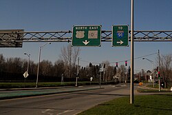
It leaves the state soon after a junction with I-91, heading into Longmeadow, Massachusetts (a part of the Springfield metropolitan area).
In Springfield, US 5 then overlaps with I-91 for about 0.5 miles (0.8 km), then separates as its own freeway crossing the Connecticut River on the South End Bridge into Agawam.
Near the town of St. Johnsbury, US 5 continues northward, following the Passumpsic River valley until it reaches Sheffield Heights.
It then turns north-northwest and crosses the divide near the Airport Road in Irasburg and follows the Black River valley into Newport.
US 5 ends at the Canada–United States border in the village of Derby Line, where the roadway continues into Canada as Route 143.
In Hartford, US 5 passed by Central Row in the downtown area, entering the city via Maple Avenue and exiting on the Bulkeley Bridge with US 6.
By 1938, US 5 bypassed downtown New Haven via the Prospect Hill, Dixwell, and West River neighborhoods, ending at Davenport and Columbus Avenues.
The Massachusetts Highway Commission noted in 1912 that between Longmeadow and Agawam, the traffic between the Pioneer Valley and Connecticut was heavier on the east side.
In 1938, due to congestion in the West Springfield town center, US 5 was moved to a newly constructed bypass from the North End Bridge to East Elm Street, where it continued north along the modern Elm Street and Riverdale Road.
[11] The 1953 Massachusetts Department of Public Works Master Plan would have relocated US 5 between Morgan Road in West Springfield and Mount Tom in Holyoke to a right-of-way similar to the current path of I-91, but this was never implemented.
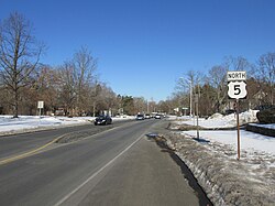
Minor deviations from the current route are found in the urban compacts of White River Junction, Burke, Coventry, and Derby Center.
[citation needed] The US 5 designation was removed when the road opposite the Connecticut River in Vermont had been improved.