U.S. Route 66 in Arizona
The highway also played an important role during the Dust Bowl as a means for refugees (also known as "Okies") to escape the ruined farmlands of the Great Plains and migrate to California.
[2][10] Less than two miles (3.2 km) east of the Goldroad Mine, US 66 crossed over Sitgreaves Pass at an elevation of 3,550 feet (1,080 m), making its slow winding descent towards the other side of the Black Mountains.
[10] Between Kingman and Seligman, I-40's more southerly and more direct path diverges from former US 66 by approximately 16 miles (26 km), putting considerable distance between former US 66 and the current Interstate.
[11][16] East of Ash Fork, the route left the high desert terrain and entered a mountainous area, covered with Ponderosa pine forests.
[11][16] Today, part of this section of former US 66/US 89 is listed on the National Register of Historic Places (NRHP) as Abandoned Route 66, Ash Fork Hill.
[8] East of town, US 66/US 89 met the Santa Fe Railway at an underpass, then curved southeast onto an abandoned road, which tied into Mountain Man Trail in front of the Bearizona Wildlife Park.
[2] US 66/US 89 continued east from the SR 64 junction outside Williams on Mountain Man Trail for 2.1 miles (3.4 km), then crossed the present-day route of I-40 diagonally onto Deer Farm Road.
The highway skirted the northern shore of Davenport Lake, then crossed present-day I-40 to the south side frontage road, known as Mountain Ranch Resort Drive.
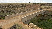
Around 4,800 feet (1,500 m) southeast of the Interstate, US 66 curved east on an abandoned highway grade to rejoin the route of I-40, where Buffalo Range Road turns sharply to the southwest.
[22] At the intersection of Hopi Drive and Navajo Boulevard, US 180 heads southeast towards Springerville and Silver City, New Mexico, concurrent for a short distance with southbound SR 77.
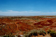
[11][16] US 66 followed the south frontage road for 3.2 miles (5.1 km), then diagonally crossed I-40 onto a now-abandoned roadway through the Painted Desert, entering Apache County.
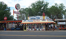
[24] However, thanks to a preservation effort, largely kicked off by Seligman-based barber Angel Delgadillo, US 66 has made a comeback and is once again a popular tourist destination for travelers from around the world.
[14] In 1853, United States Army Lieutenant A. W. Whipple traversed the northern end of New Mexico Territory to survey a route for a proposed transcontinental railroad.
Santa Fe Highway started at the Colorado River in Topock, extending north through Kingman, then east through Flagstaff to Holbrook, where it headed southeast through Springerville into New Mexico.
In response, the upstream Red Rock Bridge, owned by the Santa Fe Railway, became the new river crossing for National Old Trails Road motorists.
[30] In the middle of 1928, numerous bond issues passed by cities, states and the federal government were allocated to help begin paving work on US 66 across the nation, including a large portion of the route within Arizona.
Extensive preparation work in the form of multiple aerial surveys and a detailed study regarding finances and local construction logistics was also undertaken to aid in paving through Arizona.
[citation needed] The official 1929 Highway Department map depicted surfacing and road conditions along US 66 as being mostly unchanged since the previous year, although newspapers reported otherwise.
On June 18, 1933, the association sent a train of 200 delegates from towns along US 66 and US 89 to attend a highway hearing the next day and hold active demonstrations against Moeur's requested budget change.
"[36] The delegation included people from Kingman, Seligman, Ash Fork, Williams, Flagstaff and Holbrook as well as US 89 and US 260 supporters from Concho, Adamana, St. Johns and Prescott.
[44] Western Arizona in particular provided a great obstacle for refugees traveling down US 66 to California: they would often have trouble crossing the Black Mountains on US 66 over Sitgreaves Pass.
[60] It was fraught with hairpin turns and was the steepest along the entire route, so much so that some early travelers, too frightened at the prospect of driving such a potentially dangerous road, hired locals to navigate the winding grade.
[62] The State Highway Department contracted the Phoenix-Tempe Stone Company to construct the first six miles (9.7 km) of the new route on September 15, 1950, at a cost of $262,152 (equivalent to $2.63 million in 2023[26]).
[66] The Highway Department created another contract job in October 1951 to pave and construct a further 18 miles (29 km) of the bypass route, in hopes of speeding up the project.
Originally proposed back in the 1930s, this system of nationwide freeways would have entirely controlled access through the entry and exit ramps, as well as grade-separated interchanges with other highways, roads, and railroads.
The state government agreed not to construct the bypasses until all other sections of I-40 had been completed, in hopes of giving the US 66 towns time to adjust to the upcoming changes.
[88] However, the Arizona Department of Transportation (ADOT) continued to recognize the US 66 designation west of Sanders, establishing a signed western terminus at I-40 in Kingman.
[91] On June 26, 1985, AASHTO approved a request by the states of Arizona, New Mexico, Texas, Oklahoma, Kansas and Missouri to retire the US 66 designation from the U.S. Highway System.
[118] About 20 miles (32 km) from Kingman in Antares, Arizona is the Kozy Corner RV park,[119] which features the 'Giganticus Headicus' attraction, a 14-foot tall homemade monument resembling the Easter Island heads.
[120] The RV park is isolated, bracketed between the Peacock Mountains and Route 66 and the Burlington Northern & Santa Fe Railway, which run parallel; it began as a camp for railroad workers in the early 1900s.