U.S. Route 6 in Pennsylvania
The road continues southeast through more rural areas as it heads away from the state park, passing over the Canadian National Railway's Bessemer Subdivision railroad line.
The road heads into a business area to the west of the city of Meadville and comes to a roundabout with US 19 and the southern terminus of PA 98, at which point US 19 becomes concurrent with US 6 and US 322.
Past this interchange, the three routes reach an intersection with the southern terminus of PA 102 before curving north and entering Meadville upon crossing French Creek and a Western New York and Pennsylvania Railroad line.
The two routes leave Meadville and narrow to a two-lane undivided road, passing through wooded areas with some fields and development as it follows the French Creek and the Western New York and Pennsylvania Railroad.
The route passes through the borough of Mill Village, where it crosses under a Western New York and Pennsylvania Railroad line, and runs through a mix of farmland and woodland with some development.
At this point, US 6 heads north along with PA 8 through developed areas of the borough on South Main Street, crossing a Western New York and Pennsylvania Railroad line.
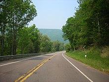
The route leaves Union City and heads through farm fields and woods, reaching a junction with PA 89 to the north of the borough of Elgin.
US 6 crosses the Allegheny River and passes through developed areas in the southern part of Warren, reaching an eastbound exit and westbound entrance at Main Avenue.
From here, the route continues southeast into the Allegheny National Forest, winding to the south parallel to a Buffalo and Pittsburgh Railroad line as it enters mountainous terrain.
The road enters the borough of Smethport and becomes Marvin Street, heading north through developed areas and coming to an intersection with the eastern terminus of PA 59.
The two routes split at the south end of Port Allegany, with US 6 heading east through wooded mountains with some farm fields and development to the north of the Allegheny River.
[1][7] US 6 enters Potter County and continues east through a mix of forested mountains and farmland with some development north of the river, passing the community of Roulette.
The road has an intersection with the northern terminus of PA 872 before it leaves Coudersport as it passes south of UPMC Cole hospital, heading southeast through wooded areas with some fields and development to the north of Mill Creek.
Following this, the road heads north of a rest area accessible from both directions and winds east through Tioga State Forest as it passes through more rugged terrain.
Here, US 6 turns south for a concurrency with PA 287, with the two routes running through a mix of farms and woods to the west of the parallel Wellsboro and Corning Railroad.
The two routes leave Wellsboro and become a two-lane road called Roosevelt Highway that heads northeast through a mix of farm- and woodland with some development.
PA 660 splits to the east and US 6 runs northeast through more rural land prior to reaching an interchange with I-99/US 15 on the western edge of the borough of Mansfield.
The route leaves Mansfield and becomes Roosevelt Highway, continuing southeast through wooded areas with some fields and reaching a junction with the southern terminus of PA 549.
US 6 continues southeast as follows a winding path that passes through a mix of farm- and woodland with some development to the northeast of the Lehigh Railway and the Susquehanna River.
[1][7] The route crosses into Wyoming County and heads into the borough of Laceyville, where it passes near developed areas and reaches an intersection with the southern terminus of PA 367.
From here, the road continues southeast through farmland and woodland with occasional development alongside the Lehigh Railway and the Susquehanna River on Roosevelt Highway, winding along.
The route continues southeast through rural areas with some industrial development as Roosevelt Highway and comes to an intersection with the northern terminus of PA 87, where it turns east as an unnamed road.
Here, the two routes turn to the southeast and narrow to two-lane undivided North State Street, passing through developed areas of the borough and crossing over Norfolk Southern Railway's Sunbury Line.
Following this interchange, the route bends northeast and then northwest as it heads between a landfill to the west and the forested Moosic Mountains to the east, crossing into the borough of Throop.
Here, the road becomes West Park Street and passes through developed areas, heading south of Wayne Memorial Hospital and coming to an intersection with PA 191.
At this point, PA 590 turns south for a concurrency with US 6 and the two routes follow Main Avenue, crossing the river and the railroad tracks and passing through the downtown area.
US 6 continues east through rural land, passing through a tract of Delaware State Forest prior to coming to a junction with the northern end of PA 739.
The two routes leave Milford and become an unnamed three-lane road with a center left-turn lane, passing through developed areas with some woodland to the northwest of the Delaware River.
[9][10] By the end of 1927, US 6 had replaced US 120 in running west from Kane to Erie (making US 120 no longer connect to its "parent" US 20) and had swapped places with US 106 via Scranton; this took it along the Jefferson Highway.
It was defined by AASHO to serve the following places in Pennsylvania: Erie, Waterford, Corry, Warren, Kane, Farmers Valley, Coudersport, Wellsboro, Canoe Camp, Mansfield, Towanda, Wyalusing, Tunkhannock, Clarks Summit, Scranton, Carbondale, Honesdale, Milford, and Matamoras.