U1 (Berlin U-Bahn)
The increasing traffic problems in Berlin at the end of the 19th century led to a search for new efficient means of transport.
Finally, after many years and negotiations, Siemens proposal for an elevated railway line from Warschauer Brücke via Hallesches Tor to Bülowstraße was approved.
The richer residents of Leipziger Straße pressed the city administration to prevent the line using their street.
The construction work had to be carried out quickly because the contract with the city of Berlin, signed with the granting of the concession, specified that the line had to be finished within two years, or a penalty of 50,000 marks would be payable.
After tough negotiations with the city of Charlottenburg it was decided to extend the line to Knie along the Tauentzienstrasse, but instead of being elevated it would be a subsurface (cut-and-cover) railway.
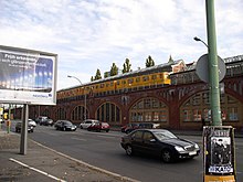
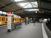
The largest part of the route, approximately 8 kilometres (5.0 mi), would be established on viaducts and connect eleven elevated stations.
This allowed many prominent Berliners to participate in the opening trip, including the Prussian minister for public works, Karl von Thielen.
The royal domain of Dahlem, which was south of Wilmersdorf and was still undeveloped, also supported a U-bahn connection and wanted it extended from Breitenbachplatz to Thielplatz.
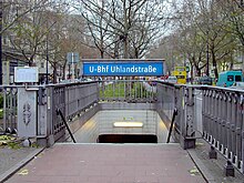
Long negotiations ensued, until finally in the summer 1910 a solution was found: an additional line would be built under the Kurfürstendamm to Uhlandstraße.
Finally the house architect of the elevated railway company, Alfred Grenander, was appointed to design the station on the recommendation of the royal police chief.
The additional line to Uhlandstraße branched at Wittenbergplatz and had no intervening stations, but it was intended to be extended to Halensee.
It is still planned to extend the line to the west and preparations were made for it in the building of Internationales Congress Centrum on Neuen Kantstraße.
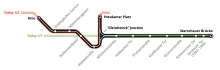
One of the most dangerous places of the entire U-Bahn network was found at the triangular rail junction at Gleisdreieck, which connected the main route between Warschauer Brücke and Zoologischer Garten with the branch line to Potsdamer Platz.
Construction began in May 1912 to replace the rail triangle with two lines built as a grade-separated cross with a new Gleisdreieck interchange station at the intersection.
As part of this work, the Nollendorfplatz station was completely rebuilt to incorporate the Schöneberg line (now U4), which had continued to be independently operated after its take over by the city of Berlin in 1920.
It also recognised that the densely populated districts of Steglitz, Wedding and Reinickendorf needed a rail connection to the then redeveloping centre around Zoologischer Garten.
Therefore, a proposal was made to build line G (now U9) from central Wedding, near Osloer Straße, through Moabit, the centre of West Berlin, near Zoo and Kurfürstendamm, the Bundesallee and the Schloßstraße to Rathaus Steglitz.
Instead of building the station with services operating, the “stub line” was simply shut down so that the rail interchange could be built under the crossing of Joachimstaler Straße and Kurfürstendamm.
After the fall of the Berlin Wall on 9 November 1989 and German reunification on 3 October 1990, it was also necessary to combine the two U-Bahn networks of the east and west again.
[3] While older plans for a continuation to Theodor-Heuss-Platz would create a line with above average passenger numbers, costs might be prohibitive compared to smaller and shorter alternatives.