U.S. Route 89 in Utah
The former provides access to several national parks and Arizona, and the latter connects I-15 with Logan, the state's only Metropolitan Statistical Area not on the Interstate.
Following the extension of the former to the Canada–US border, Interstate 15 was constructed roughly paralleling US-89 to the west and replacing US-91 south of Brigham City.
After leaving the recreation area and passing the small town of Big Water, the highway curves west through the Grand Staircase–Escalante National Monument.
US-89 stays near the monument's southern boundary,[3] crossing the East Clark Bench and The Cockscomb and passing south of the Vermilion Cliffs of the Grand Staircase.
The final "step" is the Pink Cliffs, where the highway follows alongside the Virgin River to the highest point on US-89 in southern Utah and the east end of SR-14, a summit at Long Valley Junction (elevation 7450 feet/2300 m).
[5] Although US-89 follows the I-70 freeway from Sevier to Salina, the old alignment can still be driven, and is state-maintained north of Elsinore as SR-258, SR-118 (which overlaps I-70 Business through Richfield), SR-24, and US-50.
Both highways stay mainly in the west half of the Sevier River's valley, with the faster I-70/US-89 bypassing the surface road's communities.
North of Salina, US-89 bypasses Redmond (SR-256 follows the former route through the town) and passes through Centerfield to Gunnison, where it meets SR-28 and finally turns away from the Sevier River.
US-89 splits to the north from US-6 there, skirts the west edge of Mapleton, and merges with SR-51 - the old Arrowhead Trail (US-91) - south of downtown Springville.
North of Lehi, US-89 merges with I-15 (at exit 282), which has been built on or near the old road through a gap in the Traverse Mountains (elevation 4800 feet/1500 m) into the Salt Lake Valley.
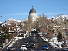
As it leaves downtown, 300 West curves northwesterly and becomes Beck Street, meeting the modern terminus of SR-186 at Victory Road at the back side of Capitol Hill.
The freeway ends after US-89 crosses SR-273, the former surface alignment of US-91 in both directions, and heads north as a four-lane road along the Wasatch foothills, to the east of Layton and Hill Air Force Base.
Beyond Ogden, US-89 continues in a general northerly direction along the thin strip between Willard Bay and the Wasatch Mountains to Brigham City, where it finally turns east away from the I-15 corridor.
US-89/US-91 turns north there, bypassing the town of Mantua to the west, and continues to ascend through Dry Canyon to Sardine Summit (elevation 5900 feet/1798 m).
[8][9] The highway was extended north to the Canada–US border near Glacier National Park in the mid-1930s,[10][11][12] though a dispute between Utah and Idaho on the one side and Wyoming on the other was not settled until 1938.
The American Association of State Highway Officials decided in favor of Utah and Idaho, placing US-89 on or near US-91 between Springville and Logan, where it split northeasterly to Yellowstone National Park.
[16] No rail line ever reached farther south,[17] and so residents of towns such as Junction, Panguitch, Alton, Glendale, and Kanab had to travel north to the railhead at Marysvale.
Carmel, allowing these communities access to the state road system, along with a connection west from the junction to Cedar City.
[20] A connection from Pigeon Hollow Junction north to Thistle was also added in 1912, following the rail line through a canyon and providing another route to Salt Lake City.
[26] In 1927, the legislature added State Route 49, an alternate southern entrance to Ogden that left SR-1 at Farmington and merged with SR-5 (US-30S) at Uintah.
[37] This replaced about eight miles (13 km) of SR-136 (the original state highway from the 1910s) at its south end,[38] but the remainder was a new roadway, through an area not previously served by improved roads.