U.S. Route 89 in Arizona
U.S. Route 89 (US 89) is a U.S. Highway in the U.S. state of Arizona that begins in Flagstaff and heads north to the Utah border northwest of Page.
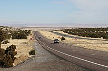
The highway proceeds northeast, passing by suburban development and the San Francisco Peaks to the west.
After the traffic circle with AZ 64, the road crosses over the Little Colorado River next to the decommissioned Cameron Suspension Bridge, which carried US 89 until 1959.
[2][3] The highway continues through unpopulated areas of the Navajo Nation, intersecting with the western terminus of US 160 near Tuba City.
[2] Near Page, the highway passes near Horseshoe Bend and Antelope Canyon before meeting the western terminus of AZ 98.
The road travels northwest, passing through Glen Canyon National Recreation Area before entering Utah.
Departing Prescott, the route followed present-day SR 89 to Ash Fork, then ran east concurrently with I-40 to Flagstaff.
[11] On February 20, 2013,[12] the main alignment of US 89 was closed in both directions approximately 25 miles (40 km) south of Page due to a landslide that caused the roadway to buckle and subside.
Alternate routes were also suggested through Las Vegas, Nevada, or Hurricane, Utah, and Marble Canyon (US 89A).
Added to the Arizona state highway system in 2013, US 89T served as a temporary detour for a closed section of US 89.
[19] Initially, the route lacked proper fencing, cattle guards, and pavement markings to support safe travel at higher speeds.
As a result, US 89T was open to local traffic only at night, and posted speed limits as low as 25 miles per hour (40 km/h).
[20] With the reopening of mainline US 89 in March 2015, the US 89T designation was retired and ownership of the route returned to the Navajo Nation in April 2015.