United States rainfall climatology
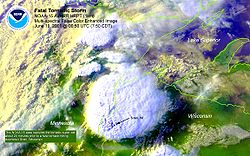
Large thunderstorm areas known as mesoscale convective complexes move through the Plains, Midwest, and Great Lakes during the warm season, contributing up to 10% of the annual precipitation to the region.
The El Niño–Southern Oscillation affects the precipitation distribution, by altering rainfall patterns across the West, Midwest, the Southeast, and throughout the tropics.
Furthermore, global La Niña meteorological events are generally associated with drier and hotter conditions and further exacerbation of droughts in California and the Southwestern and to some extent the Southeastern United States.
[2] The western part of the contiguous United States west of the 98th meridian, the mountains of the Pacific Northwest, the Willamette Valley, and the Sierra Nevada range are the wetter portions of the nation, with average rainfall exceeding 30 inches (760 mm) per year.
The drier areas are the Desert Southwest, Great Basin, valleys of northeast Arizona, eastern Utah, and central Wyoming.
[9] From September through May, extratropical cyclones from the Pacific Ocean move inland into the region due to a southward migration of the jet stream during the cold season.
[11] The West Coast occasionally experiences ocean-effect showers, usually in the form of rain at lower elevations south of the mouth of the Columbia River.
These occur whenever an Arctic air mass from western Canada is drawn westward out over the Pacific Ocean, typically by way of the Fraser Valley, returning shoreward around a center of low pressure.
[20] During El Niño events, increased precipitation is expected in California due to a more southerly, zonal, storm track.
[26] The North American Monsoon (NAM) occurs from late June or early July into September, originating over Mexico and spreading into the southwest United States by mid-July.
[10] Within the United States, it affects Arizona, New Mexico, Nevada, Utah, Colorado, West Texas, and California.
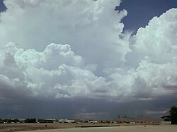
When precipitable water values near 1.32 inches (34 mm), brief but often torrential thunderstorms and the hurricane force winds and hail can occur, especially over mountainous terrain.
[29] This activity is occasionally enhanced by the passage of retrograding (westward-moving) upper cyclones moving under the subtropical ridge and the entrainment of the remnants of tropical storms.
[30][31] Tropical cyclones from the eastern Pacific contribute to the moisture within the monsoon system, and bring up to 20 percent of the average annual rainfall to southern California.
Monsoons play a vital role in managing wildfire threat by providing moisture at higher elevations and feeding desert streams.
Heavy monsoon rain can lead to excess winter plant growth, in turn a summer wildfire risk.
A lack of monsoon rain can hamper summer seeding, reducing excess winter plant growth but worsening drought.
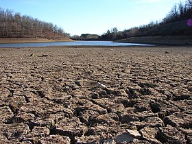
Major drought episodes in the midwestern United States are associated with an amplification of the upper tropospheric subtropical (or monsoon) ridge across the West and Plains, along with a weakening of the western edge of the "Bermuda high".
During La Niña events, the storm track shifts far enough northward to bring wetter than normal conditions (in the form of increased snowfall) to the Midwestern states, as well as hot and dry summers.
As one moves from Virginia Beach southward, summer becomes the wettest season, as convective thunderstorms created in the hot and moist tropical air mass drop brief but intense precipitation.
Along the Gulf Coast, and the south Atlantic states, decaying tropical systems added to summers peak rainfall.
During the El Niño portion of ENSO, increased precipitation falls along the Gulf coast and Southeast due to a stronger than normal, and more southerly, polar jet stream.
Once precipitable water values exceed 1.25 inches (32 mm), afternoon and evening thunderstorms break out at the western periphery of the subtropical ridge across the Southeast on a daily basis.
[46][49] During the late summer and fall, tropical cyclones move into the region from the Atlantic and Gulf of Mexico, supplying portions of the area with one-quarter of their annual rainfall, on average.
[50] Sometimes, Gulf moisture sneaks up the Front Range of Rockies as far north as the northern High Plains, bringing higher dewpoint air into states such as Wyoming and Montana.
Overall, late spring and early summer is the wettest time of year for the western portion of the region, with a winter minimum in precipitation.
[56] Although certain scientists have argued that the eastern third resemble more of an oceanic climate[57] Weather systems in the westerlies that cause precipitation move along jet stream, which migrates north into the region by summer.
[58] Mesoscale convective complexes move into the region from the Plains from late April through mid-July, with June the peak month for the western portions of the Great Lakes.
Local climates vary considerably on each island due to their topography, divisible into windward (Koʻolau) and leeward (Kona) regions based upon location relative to the higher mountains.
However, the threat of a tropical cyclone is over triple what is normal during El Niño years, so extreme shorter duration rainfall events are possible.