Upper Hessian Ridge
In the north the Gilserberg Heights transition directly into the clearly much higher Kellerwald with its prominent hills, the Jeust and the Wüstegarten; to the northeast into the Löwenstein Bottom, which is part of the Ostwaldecker Randsenken.
To the east of the three parts of the Upper Hessian Ridge is the West Hesse Depression (Westhessische Senke) in the shape of the Schwalm by the Eder tributary of the same name.
The (from a natural region perspective) very narrow, north-south oriented Neustadt Saddle is the lowest part of the Rhine-Weser watershed between the Kellerwald and the Vogelsberg.
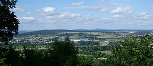
[2] The north of the Northern Vogelsberg Foreland is, in the immediate vicinity of the Neustadt Saddle, dominated by an entirely cleared plateau up to 388 metres high, around the villages of Wahlen, Arnshain und Gleimenhain in the borough of Kirtorf.
Here there are various wind farms, the views extend in good weather as far as e.g. the Hoher Meißner, 70 kilometres away to the northeast, and is unbroken in almost all directions of the compass.