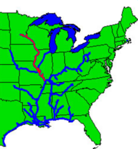
Upper Mississippi River
[citation needed] Historically, it may refer to the area above the Arkansas Post, above the confluence of Ohio River, or above Cape Girardeau.
In terms of geologic and hydrographic history, the Upper Mississippi east and south of Fort Snelling is a portion of the now-extinct Glacial River Warren which carved the valley of the Minnesota River, permitting the immense Glacial Lake Agassiz to join the world's oceans at the Gulf of Mexico.
[6][7] The Driftless Area is a portion of North America left unglaciated at that ice age's height, hence not smoothed out or covered over by previous geological processes.
The states of Minnesota, Wisconsin and Iowa, along with the federal government, have preserved certain areas of the land along this reach of the river.
[citation needed] On the upper reaches near the Minnesota-Wisconsin border, the river's floodplain is between 1.5 and 5 kilometers (between 1 and 3 mi) wide.
The largest of them, the Upper Mississippi River National Wildlife and Fish Refuge, is over 420 kilometers (260 mi) long, reaching from the Alma, Wisconsin area down to Rock Island, Illinois.
[11][12][13] The Minnesota Pollution Control Agency planned to test the entire 650-mile length (1,050 km) of the river within the state for the first time in 2024.
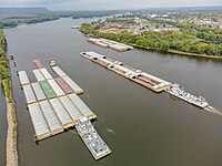
[9] The agriculture and barge transportation industries have lobbied in the late 20th and early 21st centuries for a multibillion-dollar project to upgrade the aging lock and dam system.