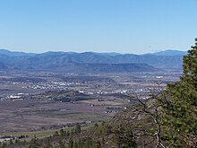
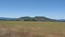
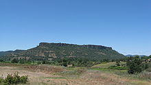
Upper and Lower Table Rock
Created by an andesitic lava flow approximately seven million years ago and shaped by erosion, they now stand about 800 feet (240 m) above the surrounding Rogue Valley.
Starting in the mid-19th century during a gold rush, the settlers forced the Takelma tribe away from the Table Rocks and into reservations.
Vernal pools atop the plateaus fill during the rainy season in winter and spring because the andesite is impermeable.
To protect these and other threatened species, the Bureau of Land Management has listed the rocks as an Area of Critical Environmental Concern since 1984.
[2] For about 2.1 million years,[1] the river deposited what is now known as the Payne Cliffs Formation by laying down a thin conglomerate, followed by arkosic sandstone and siltstone.
[2][3][4] Between 10 and 20 million years ago, the uplift that created the nearby Klamath Mountains caused an incision that formed the Rogue River valley.
[12] Humans have lived in the Table Rock area for at least 15,000 years, based on the age of Clovis points that were discovered nearby.
Major Kearny returned with volunteers from Yreka soon after, accompanied by Oregon Territory delegate Joseph Lane.
In September 1853, the Native Americans signed a peace treaty with Joseph Lane, and the Treaty with the Rogue River with Joel Palmer, which resulted in their ceding 2,500 square miles (6,500 km2) of land in exchange for $60,000, $15,000 of which was to be used to repay white settlers for losses sustained in the hostilities and $5,000 of which was set aside to purchase agricultural implements and other improvements benefitting the Native Americans.
[31] In November 1948, John Day, a local cattle rancher and developer, built a 3⁄4-mile (1.2 km) airstrip on the surface of Lower Table Rock to impress visiting celebrities from Hollywood.
However, the structure sustained $40,000 damage in 1997 when vandals unsuccessfully attempted to steal aluminum antennas from the 15-foot (4.6 m) tall fiberglass shell on the roof of the building.
[40] Four overlapping ecological regions have been identified on the Table Rocks, with considerable differences in the variety of wildlife found in each.
From the outermost base of the rocks, three regions consisting of oak savanna, chaparral, and mixed woodland surround the relatively flat tops.
This region formed when the caps were slowly eroded by the freezing and thawing of water that seeped into the ground (ice erosion), which created layers of mounded soil.
[41] Vernal pools fill in from October to June in the mounded prairie area due to the andesite's impermeability.
The average wind speed in the area is less than 6 miles per hour (10 km/h), and the annual precipitation is approximately 18 inches (460 mm) due to the rain shadow created by the Klamath Mountains.
The Takelma tribe often set fires in the oak savanna and chaparral regions to prevent brush overgrowth, creating foraging areas for animals such as deer and elk.
[9][45] Birds such as the oak titmouse, ash-throated flycatcher, white-breasted nuthatch, western bluebird, violet-green swallow, acorn woodpecker, black-headed grosbeak, and American kestrel have also been found in this region.
California black oak, Douglas fir, Pacific madrone, incense cedar, and other plants grow in the mixed woodland.
The Pacific tree frog lives in large numbers on the rocks, while tadpoles of the rarer western toad can be seen between March and May.
[45] Mammals such as California voles, Heermann's kangaroo rats, raccoons, and long-tailed weasels can also be found in this region.
Turkey vultures, rock wren, three species of hawks, and other birds patrol the cliffs on the sides of the plateaus.
[29][39][63] Over 4,600 people per year participate in guided hikes through the Table Rock Environmental Education Program, hosted by the Bureau of Land Management and The Nature Conservancy.
[64] Lower Table Rock features a walking trail, which climbs approximately 780 feet (240 m) to the top of the plateau over a distance of 1.75 miles (2.8 km).
[56] Upper Table Rock also has a walking trail, 1.25 miles (2.0 km) long, ascending approximately 720 feet (220 m).
[65][66] The Youth Conservation Corps, Boy Scouts, and the Oregon Department of Forestry built the trails leading to the tops of the Table Rocks in the early 1980s, around the same time the plateaus were being nominated as an Area of Critical Environmental Concern.
[38][39] In June 1999, only two small trees were cut when Shady Cove contractor Randy Hodges rerouted a 3⁄4-mile (1.2 km) section of the Lower Table Rock trail to accommodate the growing number of visitors.
Measures to protect the trail were implemented, such as installing rock waterbars and a layer of shale gravel over the clay.
Prior to construction, some persons with disabilities, children, or the elderly may have been prevented from using either of the Table Rocks due to the steep terrain and narrow paths.