Utah State Route 129
The route begins at the intersection of State Street (US-89) and 700 North (Lindon)/1000 South (Pleasant Grove) on border of those two cities.
From its southern terminus, the route heads west-southwest on 700 North and quickly leaves the business district to enter an industrial area.
Before completing is curve to the north, the route connects with the west end of 250 South and then continues through residential area.
North of State Street, the road becomes 1100 East as it runs along the border of American Fork and Pleasant Grove.
It then passes between the Dan Peterson School (on the west) and Intermountain Healthcare's American Fork Hospital (on the east).
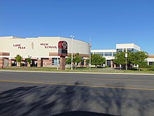
[1][3] As SR-129 fully enters Highland, it passes by the west side of Lone Peak High School.
It then connects with the west ends of 10370 North and Killarney Drive before crossing Knight Drive/Old Bish Lane.
[6]The Utah Department of Transportation (UDOT) collects data for the State Highways and Local Federal-Aid roads.
AADT is collected for major intersections and "sections where traffic volumes show a substantial increase or decrease.
"[7] The busiest section of SR-129 is between Geneva Road (SR-114) and Pleasant Grove Boulevard (SR-135), with an average of 21,000 vehicles per day.
[11] However, just a few years later, in 1933, the roadway that ran (mostly along the Colorado River) northeast from Castleton Junction to Cisico was completed.
The original SR-129 was immediately replaced (in 1933) with a road in east-central Beaver County, which was referred to as the loop off SR-21 southeast of Milford.