Uturuncu
Underneath it lies the so-called Altiplano–Puna magmatic body, a large sill[b] formed by partially molten rocks.
[15] A former sulfur mine named "Uturuncu" is situated on the mountain, close to the summit,[16][17] and was considered to be one of the highest in the world.
[33][35] The broad edifice of the volcano covers an area of about 400 square kilometres (150 sq mi) and has a volume of 85 km3–50 km3.
[26] Aside from volcanic deposits there are also traces of glaciation that has smoothened the slopes of Uturuncu,[24] as well as Pleistocene and Holocene alluvium[d] and colluvium.
[48] These watercourses are usually confined between steep bedrock walls and are characterized by gravelly beds, anastomosing channels[g] and wetlands[47] that are used to keep llamas and sheep.
[9] The eastward subduction of the Nazca Plate beneath the South American Plate has generated three volcanic belts within the Andes,[50] including the Central Volcanic Zone,[1] which spans parts of Peru, Chile, Bolivia and Argentina and includes Uturuncu.
[52] The region is characterized by the Altiplano high plateau, which reaches an elevation of 4,000 metres (13,000 ft) and is only exceeded by Tibet in dimension.
[25] Cerro San Antonio,[41] a Miocene volcano with a westward-opening collapse scar, lies just north of Uturuncu.
This subduction process at first involved a relatively flat descent of the Nazca Plate until 12 mya ago, after which it steepened.
[62] Within the last two mya, the Laguna Colorada, Tatio and Puripica Chico ignimbrites were erupted in the surrounding terrain.
[70] Its magma is extremely water-rich, consisting of about 10% water by weight;[71] in addition, about 500000 km3 of brine[h] are contained in the rocks underneath Uturuncu.
Rocks are vesicular[74] or porphyritic[i] and contain phenocrysts[j] of biotite, clinopyroxene, hornblende, ilmenite, magnetite, orthopyroxene, plagioclase and quartz[55][77] along with apatite, monazite and zircon within a rhyolite groundmass,[k][79] and define a potassium-rich calc-alkaline suite.
[82][83] Additionally, the occurrence of cumulates, gabbros, hornfels, limestones and sandstones as xenolithic phases has been reported.
[95][93] This only weakly erosive glacier deposited five sets of moraines up to 5 metres (16 ft) high within the shallow valley; the lowest of these lies at 4,800–4,850 metres (15,750–15,910 ft) elevation and appears to be a product of an early last glacial maximum between 65,000 and 37,000 years ago, earlier than the global last glacial maximum.
[97] Conversely, the uppermost of these moraines is about 16,000–14,000 years old and correlates to a glacial advance in the Altiplano that has been linked to the maximum growth of the former Lake Tauca[98] north of Uturuncu and a wet and cold climate associated with Heinrich event 1.
[99] There is little information on local climatology, but mean annual precipitation is about 100–200 millimetres per year (3.9–7.9 in/year) or even less than that, most of it originating in the Amazon basin to the east and falling during December, January and February.
[6][102] This low amount of precipitation is not adequate to sustain glaciers even though the summit of Uturuncu lies above the freezing level,[6] but it is enough to generate a seasonal snowcap on the mountain.
[1] A lower unit emplaced during the lower and middle Pleistocene (890,000–549,000 years ago[110]) makes up most of the peripheral sectors of the volcano, while an upper unit of middle to upper Pleistocene age (427,000–271,000 years ago[110]) forms its central sector[30] and is less extensive.
[37] Volcanic eruptions at Uturuncu were effusive[70] and involved the emission of voluminous lava flows (0.1–10 km3)[86] between pauses lasting between 50,000 and 180,000 years.
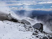
[119][122] The presence of a weak hydrothermal system is likely[123][124] at Uturuncu although probably at great depth, considering the low temperature and spread out nature of the fumarolic activity.
[65][125] Interferometric synthetic-aperture radar imaging has discovered that a region of about 1,000 square kilometres (390 sq mi) around Uturuncu is uplifting.
[127] Between 1992 and 2006, the uplift amounted to 1–2 centimetres per year (0.39–0.79 in/year) in an area 70 kilometres (43 mi) wide,[1] with seasonal variations.
[53][134] This joint uplift-subsidence has been called a "sombrero pattern" and the subsidence may reflect either a sideward or an upward migration of magma.
[135][65] A second, shallow subsidence area has been found south of Uturuncu, which may relate to changes in a hydrothermal system[130] when brines drained out underground.
[140] It has been described as an ascending diapir,[p][62][142] a plate-shaped intrusion[143] or as a growing pluton[q][145] although an alternative theory holds the ascent of volatiles along a magma column reaching to the Altiplano–Puna magmatic body as responsible for the surface deformation; in that case the uplift might reverse over time.
[151] In addition, the volcano features persistent seismic activity with occasional bursts of higher activity;[80] about three or four earthquakes occur every day at the volcano, and seismic swarms lasting minutes to hours with up to 60 earthquakes occur several times per month.
[58][153] Earthquakes are missing from the depth range of the Altiplano-Puna magmatic body but occur below it, implying that it is underlaid by brittle, cold crust.
The shallow conductors appear to relate to local volcanoes such as the Laguna Colorada vent but also Uturuncu; the latter conductor lies at 2–6 kilometres (1.2–3.7 mi) depth, is less than 10 kilometres (6.2 mi) wide and may consist of molten rock with saline aqueous fluids.