Uvs Lake Basin
The hollow, and most of the drainage basin, are situated in the Khövsgöl, Zavkhan and Uvs Provinces of north-western Mongolia, and the Mongun-Tayginsky, Ovyursky, Tes-Khemsky and Erzinsky Districts of southern Tuva.
More to the east, the Bulnai mountain range [sv] forms the southern border of Uvs Lake's drainage basin.
In Central Asia, it has the highest concentration of burial mounds, constituting around half of its archaeological sites, and many of which are older than the Egyptian pyramids.
[3][4] Archaeological searches carried out in 2007–2008 on the Por-Bazhyn ruins, which are situated on an islet in the Russian part of Tere-Khol' Lake, suggested that the enclosure was built around the middle of the second half of the 8th century, under the Uyghur Khaganate.
The lack of industry and the reliance of the inhabitants on traditional ways of life, such as nomadic pasturing, have had little impact on the landscape and have allowed the ecosystem to remain relatively free from the negative effects that human presence can impose.
[4] Both the Russian[6] and the Mongolian parts of the hollow are home to nomadic Tuvan cattle herders, who live in yurts and make up virtually all of the population.
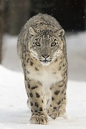
[4] Due to its location on the cusp of the Siberian and Central Asian-Mongolian terrains, the flora and fauna of the hollow exhibit a high biodiversity for mid-latitudes.
[4][8] In 1995 Greenpeace Russia prepared its proposal to nominate Ubsunur Hollow, in conjunction with Mongolia, as World Heritage Site, describing it as "one of the largest intact watersheds in Central Asia".
"[3] The nomination was submitted in conjunction with the Tuva Republic and Mongolia and included 75,000 square kilometres of forest and steppe and associated cultural and natural heritage.