Valence, Drôme
[10] The excavations on the upper part of the plateau of Lautagne (2.5 kilometres (1.6 mi) south of the centre of Valence) revealed the presence of devices of a defensive nature dating from the 1st century BC: Thus the foundation of the city could have come from a Roman military camp.
However, as early as the 4th century, Valentia faced many raids but the city within the ramparts retained its monumental adornments competing according to Ammianus Marcellinus (Histoires, XV, 11, 14), with Arles and Vienne.
[18] The city also benefitted from its position at a point of change in the regime of winds in the Rhône Valley: In the Middle Ages, vessels ascended the river only by being hauled to the col, by sweat (by men).
To reduce this burden a municipal deliberation was offered in 1714: a barracks was constructed in the current Rue Bouffier,[25] a temporary camp which quickly became inadequate to accommodate the 12,000 men and 20,000 horses stationed there.
Charles IX passed through the town during his royal tour of France (1564–1566), accompanied by the Court and the nobles of the Kingdom: His brother the Duke of Anjou, Henri de Navarre and the Cardinals of Bourbon and Lorraine.
After the convening of the Estates-General, agitation and anxiety grew until the storming of the Bastille, news of which reached the region around 20 July, causing hope but also increasing concerns of a reactionary plot of aristocrats.
[29] National guards were formed quickly, including in Valence, but communities found it insufficient, and they constituted local federations of mutual assistance, bypassing the old provincial divisions.
Four days later, on 19 August 1944, a German train loaded with nitroglycerin exploded, largely destroying the quarter of La Palla and causing 335 casualties among civilians, the military and the resistance fighters.
[43] The northern part of Valence, almost completely razed to the ground, was rebuilt and today one finds many administrative buildings in this area such as the Hotel of prefecture of the Drôme [fr], the general treasury, social security, the post office and the police headquarters.
The agglomeration is based on four alluvial terraces ranging on the left bank of the Rhone: Administratively, the commune is located in the south of the Auvergne-Rhône-Alpes region, in the northern half of the Drôme department (of which it is the prefecture), and in the south-west of the Arrondissement of Valence (of which it is the capital).
Indeed, this plain, perfectly bounded by the Rhône Valleys to the west, the Isère in the north, and the Drome to the south, gives the appearance of a cheerful orchard with peach, apricot and cherry trees, alternating with cereal and vegetable crops.
The view from the ruins of the Château de Crussol, in front after the first sharp turns in the road on leaving the Col des Limouches [fr], the plain of Valence appears as it is, a large flat surface, bordered by two reliefs which are unobscured.
Their names evoke an initial high placement to readily give a defensive view of the plain of Valence: Montélier, Montvendre, Montéléger, Montoison, Montmeyran and Beaumont-lès-Valence.
[59] Its strategic location on the Rhône (in the heart of the Rhône-Alpes region, close to Isère, Savoy and Switzerland) allows it to serve the countries of the Mediterranean Basin and the Middle East.
[59] As of July 2013, the Compagnie Nationale du Rhône (CNR) began a campaign of work, with a cost of €14 million, to develop the port to make it a place of exchange at the European level.
[62] Grenoble-Isère Airport is located 80 kilometres (50 mi) north-east of Valence along the A49 and offers flights to several European cities including London, Bristol, Dublin, Rotterdam and Warsaw.
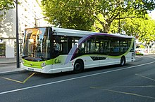
Unlike most other bike sharing systems, its management is not delegated to a business, or related to an advertising market but provided by the transport company of Valence (subsidiary of Transdev) in partnership with the Citéa transit network.
To the south, the Lautagne plateau, at an altitude of 180 metres (590 ft), determines a narrow groove between this advance from the terrace of la Léore and the Rhône, which has limited the development of the city in that direction.
The mayoral branches of Fontbarlettes, le Plan, Centre-Ville, Valence Sud and the Chamberlière are placed at the disposal of the inhabitants and are in charge of certain administrative services delegated by the Central Council.
The project would have been validated by the company of the Autoroutes du Sud de la France [fr] (ASF), but the mayor refuses for now to give a price, which would be some €500 million according to experts.
It will host the new Jean-Pommier pool, a municipal exhibition hall, a media hub with the headquarters of the radio station France Bleu Drôme Ardèche [fr] and the Le Dauphiné libéré newspaper, and finally a centre of higher education.
The Medical and Tumour Pathologies Centre welcomes gastro-enterology, haematology, oncology, haemovigilance, pulmonology – infectious diseases, dermatology, alcohol addiction, and palliative care.
The focal point of major north-south European routes and door to the Sillon Alpin [fr] for the east-west corridor in the direction of Italy and Switzerland, the territory of the Valence agglomeration has developed around innovative companies, offering a higher education, centres of excellence and an economic supply of land.
According to INSEE in 2005, the percentage of the distribution of the labour force by sector of activity was: The industries of the city include metallurgical products, textiles, leather goods, jewelry and munitions, and it also serves as a processing and trade centre for the surrounding agricultural region.
[8] The Maison des Têtes [fr], built between 1528 and 1532 by Antoine de Dorne, Consul in Valence, royal Professor at the University, the Renaissance façade with several heads carved representing the winds, fortune, time and even theology.
The Pendentif de Valence [fr], a building of Renaissance inspiration, which is probably the funerary monument of Nicolas Mistral, Canon of the Saint-Apollinaire Cathedral, seems to have been built in 1548, from a stone engraved with an inscription to that effect.
[106] At the time these rivers allowed the inhabitants to satisfy many needs and activities: Fishing, irrigation, washing, soaking, driving force for flour mills, oil, fuller and silk.
The main (Charran, Thon, Moulins and Malcontents) cross the city from east to west before joining to form the Canal de l'Épervière [fr] which then flows into the Rhône.
It bears the name of Théodore Jouvet, a generous donor who gave, to the city of Valence, the amount required for the purchase of the land and whose statue is placed near the belvedere from the Belle Époque.
In its leisure and relaxation area, the park contains restaurants, a campsite, a hotel, a swimming pool, a tennis court, billiards, bowling, walks, and offers river cruises.