Vandenberg Space Force Base
In March 1941, the Army identified approximately 86,000 acres (35,000 ha) of open ranch lands along the Central Coast of California between Lompoc and Santa Maria.
With its flat plateau, surrounding hills, numerous canyons, and relative remoteness from populated areas, the Army was convinced this portion of the Gaviota Coast was an ideal training location.
Following the Geneva Convention, the groups were kept separate and assigned various jobs within the camp, including construction, clerical work, food service, and laundry.
[3][5] After the war's conclusion in 1946, Camp Cooke became home to a maximum-security military prison, while most of the land was largely leased for agriculture and grazing.
Similar to its appeal in 1941 for the Army, Camp Cooke's vast size, remoteness, moderate climate, and coastal location made it ideal.
Missiles could be launched westward over the Pacific Ocean without flying over populated areas, and satellites could be placed into polar orbit towards the South Pole without traversing any landmass until reaching Antarctica.
[3] Following the committee's recommendation, on 16 November 1956, the Secretary of Defense directed the Army to transfer 64,000 acres (26,000 ha) to the United States Air Force.
[3] The final acquisition of 15,000 acres (6,100 ha) of land for the base occurred in 1966 to accommodate the construction of Space Launch Complex 6 for the Manned Orbiting Laboratory program.
The first successful launch of a Thor IRBM by a Royal Air Force crew took place at Vandenberg AFB on 16 April 1959.
The next month, the first missile to be removed from an operational unit and sent to Vandenberg AFB for confidence firing arrived from a Thor IRBM squadron (No.
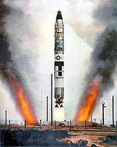
The first Atlas-D flew on 9 September 1959, and following the successful launch, General Thomas S. Power, CINCSAC, declared the Atlas ICBM to be operational.
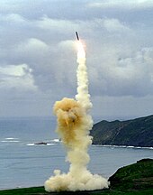
[10][7] LGM-30F Minuteman II testing began in August 1965 with the first launch conducted by Air Force Systems Command, was successful.
[3] The basic OBV consists of the upper three stages and guidance system from the Taurus orbital launch vehicle (essentially a wingless Pegasus-XL).
For instance, in August 1960, the data capsule was ejected from Discoverer XIII in orbit and recovered from the Pacific Ocean to become the first man-made object ever retrieved from space.
A week later, on 19 August 1960, the descending capsule from Discoverer XIV was snared by an aircraft in flight for the first air recovery in history.
President Richard Nixon canceled the estimated US$3 billion program in June 1969, as a result of cost overruns, completion delays, emerging new technologies, and the expense of fighting the Vietnam War.
Space Launch Complex-6 (SLC-6, pronounced as "Slick Six"), originally built for the abandoned Manned Orbital Laboratory project, was extensively modified for shuttle operations.
The original Mobile Service Tower (MST) was lowered in height and two new flame ducts were added for the shuttle's solid rocket boosters.
Additional modifications or improvements, included liquid hydrogen and liquid oxygen storage tanks, a payload preparation room, payload changeout room, a new launch tower with escape system for the shuttle crewmembers, sound suppression system and water reclamation area and a Shuttle Assembly Building were added to the original complex.
The Atlas V was developed by Lockheed Martin as part of the United States Air Force (USAF) Evolved Expendable Launch Vehicle (EELV) program.
[28] The Boeing X-37B, a reusable uncrewed spacecraft operated by the Space Force, also known as the Orbital Test Vehicle (OTV), has landed at Vandenberg in the past.
This range facilitates Department of Defense space and missile testing, including launches that place satellites into near-polar orbits.
[34][failed verification] It is Vandenberg's only National Historic Landmark that is open for regularly scheduled tours through the 30th Space Wing's Public Affairs office.
The Center preserves and displays artifacts and memorabilia to interpret the evolution of missile and spacelift activity at Vandenberg from the beginning of the Cold War through current non-classified developments in military, commercial, and scientific space endeavors.
Much of the base is rugged, mountainous, and undeveloped; predominant groundcover includes chaparral with coastal sage scrub and oak woodland.
Because of its protected nature—none of the backcountry areas are open to the public or to any kind of development—the base contains some of the highest quality coastal habitat remaining in southern or central California.
[36] The western terminus of the Santa Ynez Mountains is on the base, and is dominated by Tranquillion Peak, which rises 2,297 ft (700 m) above sea level.
Conversely, State Route 1, California's Pacific Coast Highway, avoids these coastal protected areas and instead turns inland to serve the base's eastern side.
If a set number of trespass violations have been reached during any nesting season (50 for Surf, 10 for Wall, 10 for Minuteman), the beach is closed entirely.
[39] On 22 October 2010, 19-year-old Lucas Ransom, a University of California, Santa Barbara (UCSB) student, was killed by a great white shark near Surf Beach.