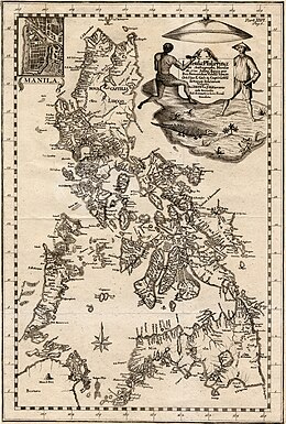
Velarde map
"Hydrographical and Chorographical Chart of the Philippine Islands"), more commonly known as the Velarde map, is a map of the Philippines made and first published in Manila in 1734 by the Jesuit cartographer Pedro Murillo Velarde [es], the engraver Nicolás de la Cruz Bagay, and the artist Francisco Suárez.
The map was created upon the behest of then governor-general Fernando Valdes y Tamon in response to an order from Philip V of Spain.
The ethnic groups and individuals depicted include Chinese Filipinos ("Sangley"), "Cafres" (or East Africans brought to the Manila slave market by the Portuguese), a Canarin (a native of India on the Konkani coast, most likely a Goan or Mangalorean), a Lascar from India, Filipino Mestizos in Spanish colonial Philippines, a Mardica (natives of Ternate and Tidore that migrated to the Philippines such as in Ternate, Cavite and Tanza, Cavite), a Japanese migrant in the Philippines ("Japon"), Spaniards or Spanish Filipinos, Spanish Criollos, Filipino Natives ("Indios"), Aetas, an Armenian, a Mughal, a native of the Malabar region and a Visayan.
Murillo Velarde also published a smaller version of the Carta Hydrographica y Chorographica de las Yslas Filipinas, one that did not include the twelve illustrations on the map's flanks.
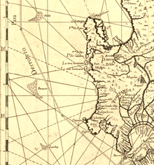
[19] The Murillo Velarde map has been instrumental in the Philippines' efforts to assert territorial rights in the South China Sea.
[21] In 2016 the Permanent Court of Arbitration in The Hague ruled in favor of the Philippines, stating that China had "no historical rights" based on their nine-dash line map.