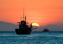
South China Sea
This name is a result of early European interest in the sea as a route from Europe and South Asia to the trading opportunities of China.
[5] During the Eastern Han dynasty (23–220 CE), China's rulers called the sea Zhang Hai (Chinese: 漲海; pinyin: Zhǎng Hǎi; lit.
Usage of the current Chinese name, Nan Hai (South Sea), gradually became widespread during the Qing dynasty.
[7] The majority of the sea came under Japanese naval control during World War II following the military acquisition of many surrounding South East Asian territories in 1941.
This was written 南支那海 until 2004, when the Japanese Foreign Ministry and other departments switched the spelling to 南シナ海, which has become the standard usage in Japan.
The Eastern and Southern limits of Singapore and Malacca Straits [A line joining Tanjong Datok, the Southeast point of Johore (1°22′N 104°17′E / 1.367°N 104.283°E / 1.367; 104.283) through Horsburgh Reef to Pulo Koko, the Northeastern extreme of Bintan Island (1°13.5′N 104°35′E / 1.2250°N 104.583°E / 1.2250; 104.583).
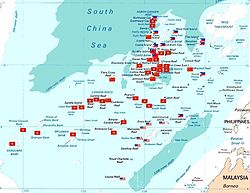
[citation needed] The South China Sea contains over 250 small islands, atolls, cays, shoals, reefs, and sandbars, most of which have no indigenous people, many of which are naturally under water at high tide, and some of which are permanently submerged.
The largest singular feature in the area of the Spratly Islands is a 100 kilometres (62 mi) wide seamount called Reed Tablemount, also known as Reed Bank, in the northeast of the group, separated from Palawan Island of the Philippines by the Palawan Trench.
Now completely submerged, with a depth of 20 metres (66 ft), it was an island until it was covered about 7,000 years ago by increasing sea levels after the last ice age.
With an area of 8,866 square kilometres (3,423 sq mi), it is one of the largest submerged atoll structures in the world.
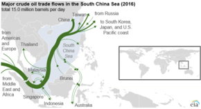
Most of the proved or probable 11 billion barrels of oil and 190 trillion cubic feet of natural gas in the South China Sea exist near undisputed shorelines.
[28][29] In 2010, the Western Central Pacific (excluding the northernmost reaches of the South China Sea closest to the PRC coast) accounted for 14% of the total world catch from commercial fishing of 11.7 million tonnes.
[38] The overlapping claims over Pedra Branca or Pulau Batu Putih including the neighbouring Middle Rocks by both Singapore and Malaysia were settled in 2008 by the International Court of Justice, awarding Pedra Branca/Pulau Batu Puteh to Singapore and the Middle Rocks to Malaysia.
[39] In July 2010, US Secretary of State Hillary Clinton called for China to resolve the territorial dispute.
[34] The US Department of Defense released a statement on August 18 where it opposed the use of force to resolve the dispute, and accused China of assertive behaviour.
[40] On July 22, 2011, one of India's amphibious assault vessels, the INS Airavat which was on a friendly visit to Vietnam, was reportedly contacted at a distance of 45 nautical miles (83 km) from the Vietnamese coast in the disputed South China Sea on an open radio channel by a vessel identifying itself as the Chinese Navy and stating that the ship was entering Chinese waters.
[41][42] The spokesperson for the Indian Navy clarified that as no ship or aircraft was visible from INS Airavat it proceeded on her onward journey as scheduled.
[44][46] In 1999, Taiwan claimed the entirety of the South China Sea islands under the Lee Teng-hui administration.
[49] In May 2014, China established an oil rig near the Paracel Islands, leading to multiple incidents between Vietnamese and Chinese ships.
[52][56] The US, although not a signatory to UNCLOS, has maintained its position that its naval vessels have consistently sailed unhindered through the South China Sea and will continue to do so.
The statement said the United Nations Convention on the Law of the Sea is "the basis for determining maritime entitlements, sovereign rights, jurisdiction and legitimate interests over maritime zones, and the 1982 UNCLOS sets out the legal framework within which all activities in the oceans and seas must be carried out.
"[60] In January 2013, the Philippines initiated arbitration proceedings against China (PRC) over issues surrounding the nine-dash line, characterization of maritime features, and EEZ.
[67] It also concluded that China's historic rights claims over the maritime areas (as opposed to land masses and territorial waters) inside the nine-dash line would have no lawful effect outside of what's entitled to under UNCLOS.
[75] The governments in support are Australia, Austria, Belgium, Canada, the Czech Republic, Denmark, Finland, France, Germany, Greece, India, Ireland, Italy, Japan, the Netherlands, New Zealand, the Philippines, Poland, Portugal, Romania, Slovakia, South Korea, Spain, Sweden, the United Kingdom, and the United States; the governments in opposition are China, Montenegro, Pakistan, Russia, Sudan, Syria, Taiwan, and Vanuatu.
[75][76] The United Nations itself does not have a position on the legal and procedural merits of the case or on the disputed claims, and the Secretary-General expressed his hope that the continued consultations on a Code of Conduct between ASEAN and China under the framework of the Declaration of the Conduct of Parties in the South China Sea will lead to increased mutual understanding among all the parties.