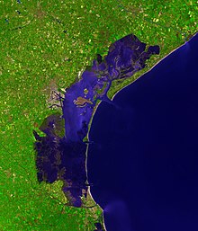
Venetian Lagoon
Its name in the Italian and Venetian languages, Laguna Veneta (cognate of Latin lacus 'lake'), has provided the English name for an enclosed, shallow embayment of salt water: a lagoon.
About 11% is permanently covered by open water, or canals, as the network of dredged channels are called, while around 80% consists of mud flats, tidal shallows and salt marshes.
[3] The most extreme are the spring tides known as the acqua alta (Italian for "high water"), which regularly flood much of Venice.
The Lagoon was formed about six to seven thousand years ago, when the marine transgression following the Ice Age flooded the upper Adriatic coastal plain.
[a] Deposition of river sediments compensated for the sinking coastal plain, and coastwise drift from the mouth of the Po tended to form sandbars that closed tidal inlets.
However, most of the inhabitants of Venice, as well as its economic core (its airport and harbor), are on the western border of the lagoon, around the former towns of Mestre and Marghera.
At the same time, however, the seagrasses started a natural process of recolonization, helping to partially restore the pristine conditions of the marine ecosystem.