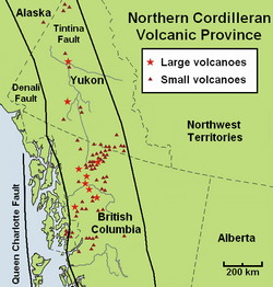
Volcanic history of the Northern Cordilleran Volcanic Province
A range of alkaline rock types not commonly found in the Western Cordillera are regionally widespread in the Northern Cordilleran Volcanic Province.
An area of continental rifting, such as the Northern Cordilleran Volcanic Province, would aid the formation of high-level reservoirs of capable size and thermal activity to maintain long-lived fractionation.
[3] In the past 15 million years, at least four large volcanoes have formed their way through dense igneous and metamorphic composed bedrock of this part of North America.
[9] Magma production during this volcanic phase was most active from seven to five million years ago and was related to a period of rifting along the Pacific and North American Plate boundary.
[2] The most recent magmatic phase ranging from two million years ago to present resulted from nearby areas of rifting during a period of compression between the Pacific and North American plates.
[2] Just west of Level Mountain lies Heart Peaks, the third most voluminous volcano of the Northern Cordilleran Volcanic Province with an area of 275 km2 (106 sq mi).
[3] A massive stratovolcano was also formed on top of the Level Mountain shield volcano 7.1 to 5.3 million years ago during this increased period of volcanism when viscous peralkaline trachyte and comendite lavas were erupted.
[3] More Miocene age volcanics of 27.5 ± 4.3 and 16.2 ± 2 million years are present at the Anderson and Moose bays of Atlin Lake in northern British Columbia that represent remnants of columnar-jointed basalt lava flows.
[3] Remnants of this prehistoric shield volcano include a cluster of 14 volcanic plugs and scattered cliff-bounded basaltic lava flows.
[3] Named for its extensive colouration, this nearly circular lava dome is up to 650 m (2,130 ft) thick and more than 10 km (6.2 mi) wide with a basaltic shield volcano forming its broad base.
This valley system exposes large comendite and trachyte lava flows of the dome, including faults of a hidden 4.5 km (2.8 mi) wide caldera.
[3] A series of lava domes were constructed in the Level Mountain Range alpine valley system 4.5 to 2.5 million years ago.
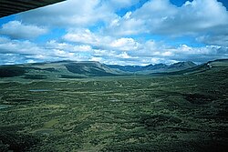
[3] These domes intrude the glacially eroded core of the 860 km3 (210 cu mi) stratovolcano and headward erosion has further modified the Level Mountain shield by incising youthful V-shaped stream canyons into the lava plateau margin.
This volcano-ice association can be recognized in three different physiographic settings, each displaying unique relationships between topography, volcanism and glacial ice.
[18] At the Edziza complex, most of the subglacial products were formed on top of the main lava plateau, which now rises at least 1,000 m (3,300 ft) in elevation above adjacent stream valleys.
[18] Just northwest of Level Mountain, the Heart Peaks shield volcano rises with a topographic prominence of 1,025 m (3,363 ft) above the Nahlin Plateau with rhyolitic lava domes capping its summit.
[19] On the divide between the head of the Omineca and Bear rivers, The Thumb rises with a topographic prominence of 180 m (590 ft) above gently sloping benchland near the crest of the Connelly Range.
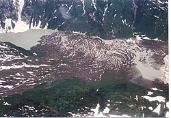
[21] More than 90% of Hoodoo Mountain was formed during this eruptive period and interlayed peralkaline phonolitic and trachytic lava flows and hyaloclastites are the main volcanics comprising the volcano.
Its smooth northern and western flanks are only slightly channeled by erosion and they curve up to a circular 2,700 m (8,900 ft) summit ridge which surrounds a central ice-filled caldera 2 km (1.2 mi) in diameter.
These flat-topped, steep-sided subglacial volcanoes were formed when magma intruded into and melted a vertical pipe in the overlying Cordilleran Ice Sheet.
[22][23][24][25] Numerous eruptions have occurred since the beginning of the Holocene epoch 10,000 years ago, when the vast Cordilleran Ice Sheet retreated rapidly at the end of the last glacial period.
[28] The other three volcanoes were formed when glacial ice existed adjacent to the associated volcanic vents, creating scoria, pillow lava and hyaloclastite breccia.
[7][55] These cinder cones were formed no more than the year 700 based on the age of burnt plant stems still rooted in former soil under 2 m (6.6 ft) of loose basaltic fragments.
[3] Two well-preserved reddish-brown basaltic cinder cones cap a small shield volcano of the Alligator Lake volcanic complex in southcentral Yukon.
[16] On the south side of the Khutzeymateen Inlet north of Prince Rupert, thick basaltic Plinian eruption tephra deposits are recognized at Crow Lagoon.
[59] In the Pleistocene Tuya Volcanic Field, small subaerial shield volcanoes and postglacial cinder cones and lava flows can be recognized.
[61] This basalt lava flow extends more than 400 m (1,300 ft) from the volcano and there is no proof Gabrielse Cone was formed during or before the Cordilleran Ice Sheet.
[63] Although the available data does not allow a clear conclusion, these observations are further indications that some Northern Cordilleran volcanoes are potentially active and that their associated hazards may be significant.
[67] An eruption from Hoodoo's summit would cause considerable melting of the ice cap to create large floods and lahars, which would have significant effects on adjacent river valleys.
[68] Currently, no volcanoes in the Northern Cordilleran Volcanic Province are monitored closely enough by the Geological Survey of Canada to ascertain how active their magma chambers are.