WISDOM Project
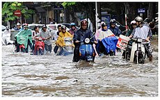
The river regularly overflows its banks in the lower Mekong area, with beneficial effects, such as the accumulation of fertile sediment.
Beside these extreme floods the Mekong Delta region encounters further challenges and problems, such as deteriorating water quality due to strong pesticide use in rice farming areas, unfiltered discharge of rural and industrial waste water, changing climatic conditions with predicted sea level rise, and thereupon resulting salinization and acidification, species / habitats diminish, and regulatory measures (hydropower) is ongoing at the upper reaches of the Mekong.
The interactions between nature and human beings make the Mekong Delta a complex system, requiring a more and more adapted regulation, based on accurate information concerning the different factors entering the equation.
This allows answers which combine the different factors relevant to the question, for example in case of a flood: How much agricultural land has been affected?
The main objectives of the work package are to understand the needs of potential end-users of the Information System, to complete the institutional analysis of the water sector and to build and sustain knowledge management capacity in the Mekong Delta.
During a multi-stage developing process evaluation of current prototypes is provided in order to progressively enhance functionality of consecutive systems.
Therefore, WP4000 dedicates approximately half of the work volume to studies investigating water quality issues in the delta.
A continuative objective is to understand the diversity of livelihoods and subsistence strategies and how they are shaped by both, environmental and demographic changes and the ongoing political and institutional transformation process.
Thirdly different thematic, temporal and spatial scales of remote sensing technologies should be analyser towards the use ability to monitor water resources.
Ontologies describing spatial-, thematic-, and temporal reference aspects have been implemented allowing a semantic enrichment of the datasets and with that enable fast data retrieval by meaningful search attributes as e.g. finding all data in a specific administrative unit belonging to a specific theme.
This allows for a dynamic retrieval of rendered maps of requested spatial datasets from the data management system.