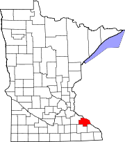
Wabasha County, Minnesota
An area on the Mississippi River's west bank, originally called Cratte's Landing, had grown into a town named Wabasha, then a city, and when the legislature created the county west of the river around this city, Wabasha was designated the county seat.
The city had been named for three successive chiefs of Mississippi bands of Dakota Indians.
Wabasha County lies on Minnesota's border with Wisconsin (across the Mississippi River.
The combined Whitewater then enters the southeastern part of Wabasha County, flowing northeast to its discharge point into the Mississippi.
The Zumbro River flows east-northeast through the county to its discharge point into the Mississippi.
The county terrain consists of low rolling hills, considerably rutted by drainages, with all available area devoted to agriculture.
[5] The terrain slopes to the east and south, with its highest point on its upper west border at 1,191 ft (363 m) ASL.


